Mosteiros geodata
Mosteiros (Azores) is a populated place; located in Portugal in Atlantic/Azores (GMT+0) time zone. With population of 1,123 people, there are 734 cities with bigger population in this country. Compared to other cities in Portugal, 85.1% of cities are located further ↑North; 96.2% of cities are located further →East and 53.3% of cities have higher elevation than Mosteiros. Note1


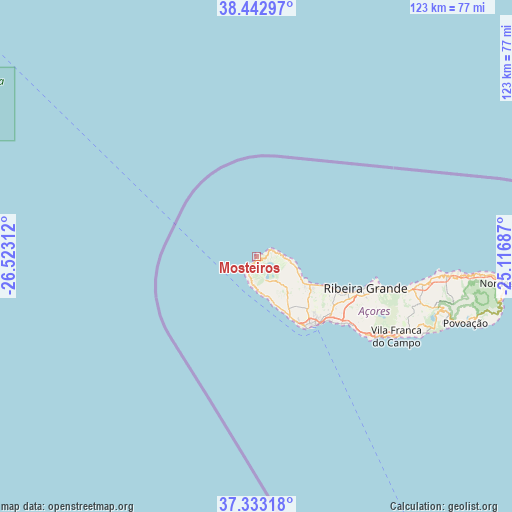
Mosteiros GPS coordinates[2]
37° 53' 24.612" North, 25° 49' 11.964" West
| Map corner | latitude | longitude |
|---|---|---|
| Upper-left | 38.44297°, | -26.52312° |
| Center: | 37.89017°, | -25.81999° |
| Lower-right: | 37.33318°, | -25.11687° |
| Map W x H: | 123.4×123.4 km | = 76.7×76.7mi |
| max Lat: | 42.11337° ⇑85.1% North |
| Mosteiros: | 37.89017° |
| min Lat: | ⇓14.9% South 32.6448° |
| min Long | Mosteiros | max Long |
| -31.17847° | -25.81999° | -6.27308° |
| W 3.8%⇐ | ⇒96.2% E |
Elevation
Elevation of Mosteiros is 99 m = 325 ft, and this is 78 m = 256 ft below average elevation for this country.
| Max E: |
1008 m = 3307 ft | 53.3% |
| Avg. | 177 m = 581 ft | |
| Mosteiros | 99 m = 325 ft | |
Min E: |
-128 m = -420 ft | 46.7% |
See also: Portugal elevation on elevation.city.
Geographical zone
Mosteiros is located in North temperate zone (between Tropic of Cancer and the Arctic Circle). Distance of this Northern Tropic circle is 1607.1 km =998.6 mi to South.| Distance of | km | miles | from Mosteiros |
|---|---|---|---|
| North Pole | 5794.1 | 3600.3 | to North |
| Arctic Circle | 3188.2 | 1981.1 | to North |
| Tropic Cancer | 1607.1 | 998.6 | to South |
| Equator | 4213 | 2617.8 | to South |


Nearby cities:
15 places around Mosteiros: (largest is in red/bold)
• Arrifes
17.3 km =10.7 mi,  142°
142°
• Cabouco
26.1 km =16.2 mi,  121°
121°
• Fajã de Baixo
21.6 km =13.4 mi, 136°
• Fenais da Luz
17.2 km =10.7 mi,  114°
114°
• Lagoa
27.1 km =16.8 mi,  126°
126°
• Ponta Delgada
21.4 km =13.3 mi, 141°
• Rabo de Peixe
22.7 km =14.1 mi, 113°
• Relva
17.7 km =11 mi,  149°
149°
• Ribeira Grande
27.3 km =17 mi, 106°
• Ribeira Seca
26.5 km =16.5 mi, 107°
• Rosto de Cão
21.6 km =13.4 mi, 136°
• Sete Cidades
4.2 km =2.6 mi, 147°
• São Roque
21.8 km =13.5 mi, 133°
• São Vicente
15.7 km =9.8 mi, 120°
• Água de Pau
32.9 km =20.4 mi, 124°
Sources, notices
• [Note1] Compared only with cities in Portugal existing in our database
• [Src1] Map data: © OpenStreetMap contributors (CC-BY-SA)
• [Src2] Other city data from geonames.org with taken over terms of usage.
• [Src3] Geographical zone / Annual Mean Temperature by Robert A. Rohde @ Wikipedia
