Mengellang geodata
Mengellang (Ngarchelong) is a seat of a first-order administrative division; located in Palau in Pacific/Palau (GMT+9) time zone. With population of 488 people, there are 4 cities with bigger population in this country. Compared to other cities in Palau, 94.1% of cities are located further ↓South; 76.5% of cities are located further ←West and 94.1% of cities have lower elevation than Mengellang. Note1


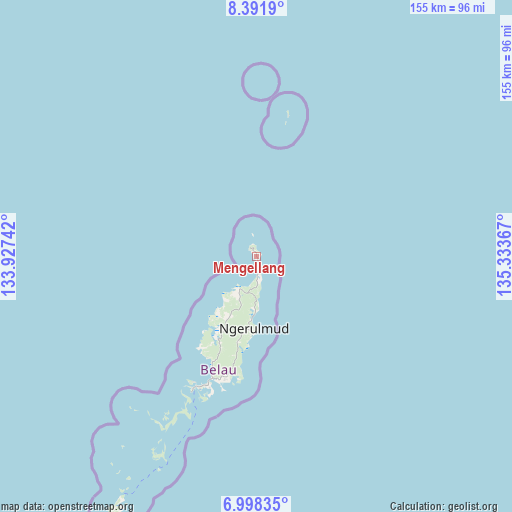
Mengellang GPS coordinates[2]
7° 41' 44.52" North, 134° 37' 49.944" East
| Map corner | latitude | longitude |
|---|---|---|
| Upper-left | 8.3919°, | 133.92742° |
| Center: | 7.6957°, | 134.63054° |
| Lower-right: | 6.99835°, | 135.33367° |
| Map W x H: | 154.9×155 km | = 96.3×96.3mi |
| max Lat: | 8.08228° ⇑5.9% North |
| Mengellang: | 7.6957° |
| min Lat: | ⇓94.1% South 3.00488° |
| min Long | Mengellang | max Long |
| 131.12168° | 134.63054° | 134.71725° |
| W 76.5%⇐ | ⇒23.5% E |
Elevation
Elevation of Mengellang is 59 m = 194 ft, and this is 34.3 m = 113 ft above average elevation for this country.
| Max E: |
72 m = 236 ft | 5.9% |
| Mengellang | 59 m 194 ft | |
| Avg. | 24.7 m = 81 ft | |
Min E: |
7 m = 23 ft | 94.1% |
See also: Palau elevation on elevation.city.
Geographical zone
Mengellang is located in North Torrid zone (between Equator and Tropic of Cancer). Distance of Equator is 855.7 km =531.7 mi to South.| Distance of | km | miles | from Mengellang |
|---|---|---|---|
| North Pole | 9151.4 | 5686.4 | to North |
| Arctic Circle | 6545.5 | 4067.2 | to North |
| Tropic Cancer | 1750.2 | 1087.5 | to North |
| Equator | 855.7 | 531.7 | to South |


Nearby cities:
15 places around Mengellang: (largest is in red/bold)
• Angaur State
103.7 km =64.4 mi,  212°
212°
• Imeong Hamlet
21.5 km =13.4 mi, 211°
• Kayangel
44 km =27.3 mi,  12°
12°
• Kloulklubed
83.6 km =51.9 mi, 209°
• Koror
43.2 km =26.8 mi,  203°
203°
• Koror Town
42.7 km =26.5 mi, 203°
• Melekeok Village
22.3 km =13.9 mi,  178°
178°
• Ngardmau
11.4 km =7.1 mi, 212°
• Ngchemiangel
32.5 km =20.2 mi, 211°
• Ngchesar Hamlet
25.3 km =15.7 mi,  185°
185°
• Ngereklmadel
28.1 km =17.5 mi, 214°
• Ngerkeai
15.7 km =9.8 mi, 177°
• Ngerulmud
21.7 km =13.5 mi, 181°
• Ngetkib
39 km =24.2 mi, 199°
• Ulimang
8.1 km =5 mi,  170°
170°
Sources, notices
• [Note1] Compared only with cities in Palau existing in our database
• [Src1] Map data: © OpenStreetMap contributors (CC-BY-SA)
• [Src2] Other city data from geonames.org with taken over terms of usage.
• [Src3] Geographical zone / Annual Mean Temperature by Robert A. Rohde @ Wikipedia
