Kayangel geodata
Kayangel is a seat of a first-order administrative division; located in Palau in Pacific/Palau (GMT+9) time zone. With population of 188 people, there are 10 cities with bigger population in this country. Compared to other cities in Palau, 100% of cities are located further ↓South; 100% of cities are located further ←West and 94.1% of cities have higher elevation than Kayangel. Note1


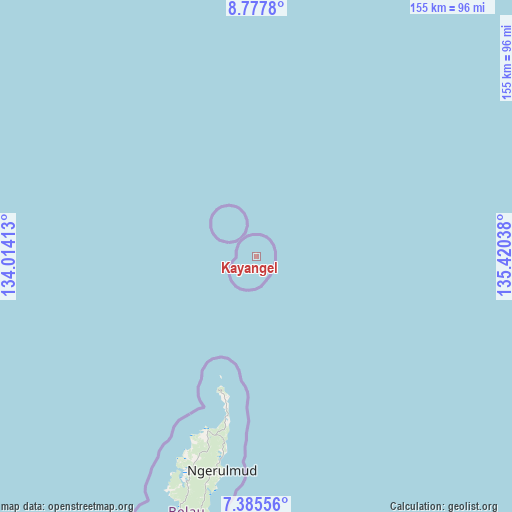
Kayangel GPS coordinates[2]
8° 4' 56.208" North, 134° 43' 2.1" East
| Map corner | latitude | longitude |
|---|---|---|
| Upper-left | 8.7778°, | 134.01413° |
| Center: | 8.08228°, | 134.71725° |
| Lower-right: | 7.38556°, | 135.42038° |
| Map W x H: | 154.8×154.8 km | = 96.2×96.2mi |
| max Lat: | 8.08228° ⇑0% North |
| Kayangel: | 8.08228° |
| min Lat: | ⇓100% South 3.00488° |
| min Long | Kayangel | max Long |
| 131.12168° | 134.71725° | 134.71725° |
| W 100%⇐ | ⇒0% E |
Elevation
Elevation of Kayangel is 9 m = 30 ft, and this is 15.7 m = 52 ft below average elevation for this country.
| Max E: |
72 m = 236 ft | 94.1% |
| Avg. | 24.7 m = 81 ft | |
| Kayangel | 9 m = 30 ft | |
Min E: |
7 m = 23 ft | 5.9% |
See also: Palau elevation on elevation.city.
Geographical zone
Kayangel is located in North Torrid zone (between Equator and Tropic of Cancer). Distance of Equator is 898.7 km =558.4 mi to South.| Distance of | km | miles | from Kayangel |
|---|---|---|---|
| North Pole | 9108.4 | 5659.7 | to North |
| Arctic Circle | 6502.5 | 4040.5 | to North |
| Tropic Cancer | 1707.3 | 1060.9 | to North |
| Equator | 898.7 | 558.4 | to South |


Nearby cities:
15 places around Kayangel: (largest is in red/bold)
• Angaur State
145.9 km =90.7 mi,  206°
206°
• Imeong Hamlet
64.7 km =40.2 mi,  198°
198°
• Kloulklubed
126.4 km =78.5 mi, 203°
• Koror
86.8 km =53.9 mi, 198°
• Koror Town
86.3 km =53.6 mi, 197°
• Melekeok Village
65.8 km =40.9 mi,  187°
187°
• Mengellang
44 km =27.3 mi, 192°
• Ngardmau
54.8 km =34.1 mi, 196°
• Ngchemiangel
75.5 km =46.9 mi, 200°
• Ngchesar Hamlet
69.2 km =43 mi, 189°
• Ngereklmadel
70.8 km =44 mi, 201°
• Ngerkeai
59.4 km =36.9 mi, 188°
• Ngerulmud
65.5 km =40.7 mi, 189°
• Ngetkib
82.9 km =51.5 mi, 195°
• Ulimang
51.6 km =32.1 mi, 189°
Sources, notices
• [Note1] Compared only with cities in Palau existing in our database
• [Src1] Map data: © OpenStreetMap contributors (CC-BY-SA)
• [Src2] Other city data from geonames.org with taken over terms of usage.
• [Src3] Geographical zone / Annual Mean Temperature by Robert A. Rohde @ Wikipedia
