Ngerulmud geodata
Ngerulmud (Melekeok) is a capital of a political entity; located in Palau in Pacific/Palau (GMT+9) time zone. In our database, there are 16 cities with bigger population. Compared to other cities in Palau, 64.7% of cities are located further ↓South; 70.6% of cities are located further ←West and 100% of cities have lower elevation than Ngerulmud. Note1


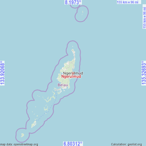
Ngerulmud GPS coordinates[2]
7° 30' 2.772" North, 134° 37' 25.68" East
| Map corner | latitude | longitude |
|---|---|---|
| Upper-left | 8.1973°, | 133.92068° |
| Center: | 7.50077°, | 134.6238° |
| Lower-right: | 6.80312°, | 135.32693° |
| Map W x H: | 155×155 km | = 96.3×96.3mi |
| max Lat: | 8.08228° ⇑35.3% North |
| Ngerulmud: | 7.50077° |
| min Lat: | ⇓64.7% South 3.00488° |
| min Long | Ngerulmud | max Long |
| 131.12168° | 134.6238° | 134.71725° |
| W 70.6%⇐ | ⇒29.4% E |
Elevation
Elevation of Ngerulmud is 72 m = 236 ft, and this is 47.3 m = 155 ft above average elevation for this country.
| Max E: |
72 m = 236 ft | 0% |
| Ngerulmud | 72 m 236 ft | |
| Avg. | 24.7 m = 81 ft | |
Min E: |
7 m = 23 ft | 100% |
See also: Palau elevation on elevation.city.
Geographical zone
Ngerulmud is located in North Torrid zone (between Equator and Tropic of Cancer). Distance of Equator is 834 km =518.2 mi to South.| Distance of | km | miles | from Ngerulmud |
|---|---|---|---|
| North Pole | 9173.1 | 5699.9 | to North |
| Arctic Circle | 6567.2 | 4080.7 | to North |
| Tropic Cancer | 1771.9 | 1101 | to North |
| Equator | 834 | 518.2 | to South |


Nearby cities:
15 places around Ngerulmud: (largest is in red/bold)
• Angaur State
85.7 km =53.3 mi,  219°
219°
• Imeong Hamlet
11.2 km =7 mi,  287°
287°
• Kayangel
65.5 km =40.7 mi,  9°
9°
• Kloulklubed
65.2 km =40.5 mi, 218°
• Koror
24.4 km =15.2 mi, 222°
• Koror Town
23.8 km =14.8 mi, 222°
• Melekeok Village
1.5 km =0.9 mi,  111°
111°
• Mengellang
21.7 km =13.5 mi,  1°
1°
• Ngardmau
13.3 km =8.3 mi,  335°
335°
• Ngchemiangel
17.3 km =10.7 mi,  249°
249°
• Ngchesar Hamlet
3.8 km =2.4 mi,  203°
203°
• Ngereklmadel
15.3 km =9.5 mi,  264°
264°
• Ngerkeai
6.1 km =3.8 mi, 12°
• Ngetkib
19.3 km =12 mi, 218°
• Ulimang
13.9 km =8.6 mi, 8°
Sources, notices
• [Note1] Compared only with cities in Palau existing in our database
• [Src1] Map data: © OpenStreetMap contributors (CC-BY-SA)
• [Src2] Other city data from geonames.org with taken over terms of usage.
• [Src3] Geographical zone / Annual Mean Temperature by Robert A. Rohde @ Wikipedia
