Musay‘īd geodata
Musay‘īd (Al Wakrah) is a populated place; located in Qatar in Asia/Qatar (GMT+3) time zone. With population of 5,769 people, there are 7 cities with bigger population in this country. Compared to other cities in Qatar, 94.1% of cities are located further ↑North; 94.1% of cities are located further ←West and 76.5% of cities have higher elevation than Musay‘īd. Note1


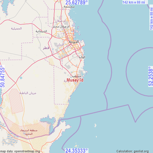
Musay‘īd GPS coordinates[2]
24° 59' 32.136" North, 51° 33' 2.412" East
| Map corner | latitude | longitude |
|---|---|---|
| Upper-left | 25.62789°, | 50.84755° |
| Center: | 24.99226°, | 51.55067° |
| Lower-right: | 24.35333°, | 52.2538° |
| Map W x H: | 141.7×141.7 km | = 88×88mi |
| max Lat: | 26.13978° ⇑94.1% North |
| Musay‘īd: | 24.99226° |
| min Lat: | ⇓5.9% South 24.7437° |
| min Long | Musay‘īd | max Long |
| 50.78227° | 51.55067° | 51.60337° |
| W 94.1%⇐ | ⇒5.9% E |
Elevation
Elevation of Musay‘īd is 7 m = 23 ft, and this is 10.8 m = 35 ft below average elevation for this country.
| Max E: |
56 m = 184 ft | 76.5% |
| Avg. | 17.8 m = 58 ft | |
| Musay‘īd | 7 m = 23 ft | |
Min E: |
4 m = 13 ft | 23.5% |
See also: Qatar elevation on elevation.city.
Geographical zone
Musay‘īd is located in North temperate zone (between Tropic of Cancer and the Arctic Circle). Distance of this Northern Tropic circle is 173 km =107.5 mi to South.| Distance of | km | miles | from Musay‘īd |
|---|---|---|---|
| North Pole | 7228.2 | 4491.4 | to North |
| Arctic Circle | 4622.3 | 2872.2 | to North |
| Tropic Cancer | 173 | 107.5 | to South |
| Equator | 2778.9 | 1726.7 | to South |


Nearby cities:
15 places around Musay‘īd: (largest is in red/bold)
• Abū Samrah
77.6 km =48.2 mi,  249°
249°
• Al Ghuwayrīyah
97.9 km =60.8 mi,  341°
341°
• Al Jumaylīyah
82.8 km =51.4 mi,  326°
326°
• Al Khawr
77 km =47.8 mi,  356°
356°
• Al Wakrah
20.6 km =12.8 mi,  14°
14°
• Al Wukayr
17.7 km =11 mi, 355°
• Ar Rayyān
35.7 km =22.2 mi, 339°
• Ash Shīḩānīyah
53.5 km =33.2 mi,  321°
321°
• Az̧ Z̧a‘āyin
65.4 km =40.6 mi,  354°
354°
• Doha
32.7 km =20.3 mi, 356°
• Dukhān
91 km =56.5 mi,  301°
301°
• Fuwayriţ
116.3 km =72.3 mi, 351°
• Umm Bāb
78.8 km =49 mi,  288°
288°
• Umm Şalāl Muḩammad
49.2 km =30.6 mi, 342°
• Umm Şalāl ‘Alī
55.3 km =34.4 mi, 343°
Sources, notices
• [Note1] Compared only with cities in Qatar existing in our database
• [Src1] Map data: © OpenStreetMap contributors (CC-BY-SA)
• [Src2] Other city data from geonames.org with taken over terms of usage.
• [Src3] Geographical zone / Annual Mean Temperature by Robert A. Rohde @ Wikipedia
