Slobozia geodata
Slobozia (Ialomiţa) is a seat of a first-order administrative division; located in Romania in Europe/Bucharest (GMT+3) time zone. With population of 52,710 people, there are 48 cities with bigger population in this country. Compared to other cities in Romania, 83.9% of cities are located further ↑North; 89.2% of cities are located further ←West and 96.9% of cities have higher elevation than Slobozia. Note1


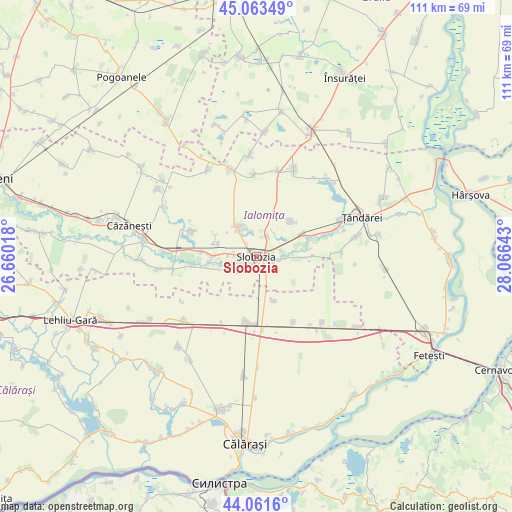
Slobozia GPS coordinates[2]
44° 33' 52.92" North, 27° 21' 47.88" East
| Map corner | latitude | longitude |
|---|---|---|
| Upper-left | 45.06349°, | 26.66018° |
| Center: | 44.5647°, | 27.3633° |
| Lower-right: | 44.0616°, | 28.06643° |
| Map W x H: | 111.4×111.4 km | = 69.2×69.2mi |
| max Lat: | 48.23793° ⇑83.9% North |
| Slobozia: | 44.5647° |
| min Lat: | ⇓16.1% South 43.65638° |
| min Long | Slobozia | max Long |
| 20.31667° | 27.3633° | 29.65403° |
| W 89.2%⇐ | ⇒10.8% E |
Elevation
Elevation of Slobozia is 24 m = 79 ft, and this is 230.9 m = 758 ft below average elevation for this country.
| Max E: |
1278 m = 4193 ft | 96.9% |
| Avg. | 254.9 m = 836 ft | |
| Slobozia | 24 m = 79 ft | |
Min E: |
-2 m = -7 ft | 3.1% |
See also: Slobozia elevation on elevation.city.
Geographical zone
Slobozia is located in North temperate zone (between Tropic of Cancer and the Arctic Circle). Distance of this Northern Tropic circle is 2349.2 km =1459.7 mi to South.| Distance of | km | miles | from Slobozia |
|---|---|---|---|
| North Pole | 5051.9 | 3139.1 | to North |
| Arctic Circle | 2446 | 1519.9 | to North |
| Tropic Cancer | 2349.2 | 1459.7 | to South |
| Equator | 4955.1 | 3079 | to South |


Nearby cities:
15 places around Slobozia: (largest is in red/bold)
• Amara
6.9 km =4.3 mi,  327°
327°
• Bucu
11.2 km =7 mi,  66°
66°
• Buești
14.1 km =8.8 mi,  260°
260°
• Ciulniţa
3.6 km =2.2 mi,  196°
196°
• Constantin Brâncoveanu
10.4 km =6.5 mi,  157°
157°
• Cosâmbeşti
5.7 km =3.5 mi,  96°
96°
• Dragalina
15.1 km =9.4 mi,  194°
194°
• Drajna Nouă
15.9 km =9.9 mi,  175°
175°
• Gheorghe Doja
15.1 km =9.4 mi,  292°
292°
• Gheorghe Lazăr
10.3 km =6.4 mi,  41°
41°
• Misleanu
11.9 km =7.4 mi,  275°
275°
• Mărculești
12.1 km =7.5 mi,  88°
88°
• Perieţi
11.7 km =7.3 mi, 261°
• Poiana
8.5 km =5.3 mi, 258°
• Păltinișu
4.9 km =3 mi,  271°
271°
Sources, notices
• [Note1] Compared only with cities in Romania existing in our database
• [Src1] Map data: © OpenStreetMap contributors (CC-BY-SA)
• [Src2] Other city data from geonames.org with taken over terms of usage.
• [Src3] Geographical zone / Annual Mean Temperature by Robert A. Rohde @ Wikipedia
