Cosâmbeşti geodata
Cosâmbeşti (Ialomiţa) is a seat of a second-order administrative division; located in Romania in Europe/Bucharest (GMT+3) time zone. In our database, there are 7076 cities with bigger population. Compared to other cities in Romania, 84% of cities are located further ↑North; 90.1% of cities are located further ←West and 97% of cities have higher elevation than Cosâmbeşti. Note1


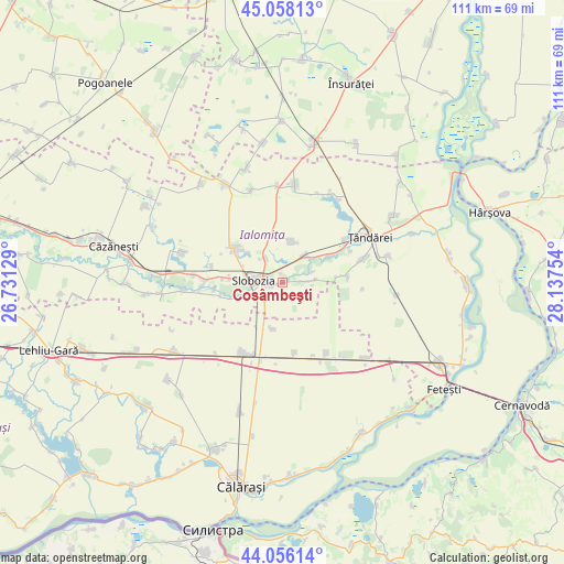
Cosâmbeşti GPS coordinates[2]
44° 33' 33.444" North, 27° 26' 3.876" East
| Map corner | latitude | longitude |
|---|---|---|
| Upper-left | 45.05813°, | 26.73129° |
| Center: | 44.55929°, | 27.43441° |
| Lower-right: | 44.05614°, | 28.13754° |
| Map W x H: | 111.4×111.4 km | = 69.2×69.2mi |
| max Lat: | 48.23793° ⇑84% North |
| Cosâmbeşti: | 44.55929° |
| min Lat: | ⇓16% South 43.65638° |
| min Long | Cosâmbeşti | max Long |
| 20.31667° | 27.43441° | 29.65403° |
| W 90.1%⇐ | ⇒9.9% E |
Elevation
Elevation of Cosâmbeşti is 23 m = 75 ft, and this is 231.9 m = 761 ft below average elevation for this country.
| Max E: |
1278 m = 4193 ft | 97% |
| Avg. | 254.9 m = 836 ft | |
| Cosâmbeşti | 23 m = 75 ft | |
Min E: |
-2 m = -7 ft | 3% |
See also: Romania elevation on elevation.city.
Geographical zone
Cosâmbeşti is located in North temperate zone (between Tropic of Cancer and the Arctic Circle). Distance of this Northern Tropic circle is 2348.6 km =1459.4 mi to South.| Distance of | km | miles | from Cosâmbeşti |
|---|---|---|---|
| North Pole | 5052.5 | 3139.5 | to North |
| Arctic Circle | 2446.6 | 1520.2 | to North |
| Tropic Cancer | 2348.6 | 1459.4 | to South |
| Equator | 4954.5 | 3078.6 | to South |


Nearby cities:
15 places around Cosâmbeşti: (largest is in red/bold)
• Amara
11.3 km =7 mi,  304°
304°
• Bucu
6.9 km =4.3 mi,  42°
42°
• Ciulniţa
7.3 km =4.5 mi,  246°
246°
• Constantin Brâncoveanu
9.2 km =5.7 mi,  190°
190°
• Drajna Nouă
15.8 km =9.8 mi,  195°
195°
• Frățilești
14.8 km =9.2 mi,  65°
65°
• Gheorghe Lazăr
8.3 km =5.2 mi,  8°
8°
• Mărculești
6.5 km =4 mi,  82°
82°
• Ograda
12.4 km =7.7 mi,  60°
60°
• Perişoru
15.2 km =9.4 mi,  142°
142°
• Poiana
14 km =8.7 mi,  265°
265°
• Păltinișu
10.6 km =6.6 mi, 273°
• Slobozia
5.7 km =3.5 mi,  276°
276°
• Sudiţi
13.4 km =8.3 mi, 78°
• Tudor Vladimirescu
13.9 km =8.6 mi,  170°
170°
Sources, notices
• [Note1] Compared only with cities in Romania existing in our database
• [Src1] Map data: © OpenStreetMap contributors (CC-BY-SA)
• [Src2] Other city data from geonames.org with taken over terms of usage.
• [Src3] Geographical zone / Annual Mean Temperature by Robert A. Rohde @ Wikipedia
