Dăroaia geodata
Dăroaia (Alba) is a populated place; located in Romania in Europe/Bucharest (GMT+3) time zone. With population of 570 people, there are 6427 cities with bigger population in this country. Compared to other cities in Romania, 62.3% of cities are located further ↓South; 83.7% of cities are located further →East and 93.9% of cities have lower elevation than Dăroaia. Note1


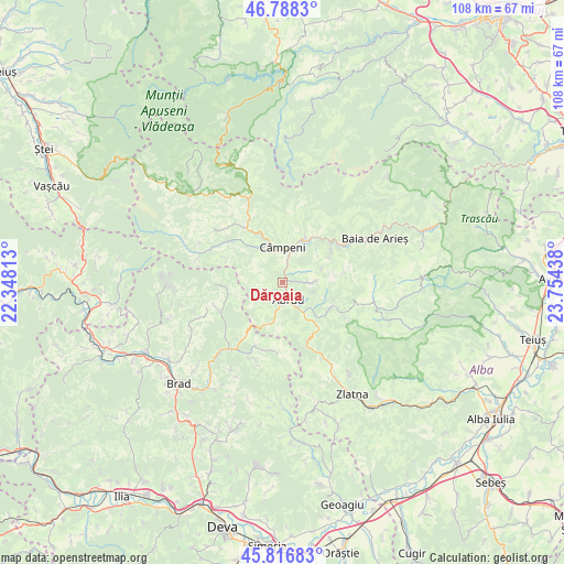
Dăroaia GPS coordinates[2]
46° 18' 16.992" North, 23° 3' 4.5" East
| Map corner | latitude | longitude |
|---|---|---|
| Upper-left | 46.7883°, | 22.34813° |
| Center: | 46.30472°, | 23.05125° |
| Lower-right: | 45.81683°, | 23.75438° |
| Map W x H: | 108×108 km | = 67.1×67.1mi |
| max Lat: | 48.23793° ⇑37.7% North |
| Dăroaia: | 46.30472° |
| min Lat: | ⇓62.3% South 43.65638° |
| min Long | Dăroaia | max Long |
| 20.31667° | 23.05125° | 29.65403° |
| W 16.3%⇐ | ⇒83.7% E |
Elevation
Elevation of Dăroaia is 592 m = 1942 ft, and this is 337.1 m = 1106 ft above average elevation for this country.
| Max E: |
1278 m = 4193 ft | 6.1% |
| Dăroaia | 592 m 1942 ft | |
| Avg. | 254.9 m = 836 ft | |
Min E: |
-2 m = -7 ft | 93.9% |
See also: Romania elevation on elevation.city.
Geographical zone
Dăroaia is located in North temperate zone (between Tropic of Cancer and the Arctic Circle). Distance of this North polar circle is 2252.6 km =1399.7 mi to North.| Distance of | km | miles | from Dăroaia |
|---|---|---|---|
| North Pole | 4858.5 | 3018.9 | to North |
| Arctic Circle | 2252.6 | 1399.7 | to North |
| Tropic Cancer | 2542.7 | 1580 | to South |
| Equator | 5148.6 | 3199.2 | to South |


Nearby cities:
15 places around Dăroaia: (largest is in red/bold)
• Abrud
3.5 km =2.2 mi,  164°
164°
• Abrud-Sat
2.7 km =1.7 mi, 163°
• Bistra
9 km =5.6 mi,  24°
24°
• Blideşti
6.3 km =3.9 mi,  94°
94°
• Blăjeni
14.1 km =8.8 mi,  235°
235°
• Bucium
10.8 km =6.7 mi,  114°
114°
• Bucium
15 km =9.3 mi,  121°
121°
• Ciuruleasa
6.2 km =3.9 mi,  192°
192°
• Câmpeni
6.9 km =4.3 mi,  359°
359°
• Lupşa
13.3 km =8.3 mi,  58°
58°
• Mușca
10.9 km =6.8 mi, 57°
• Roșia Montană
6.3 km =3.9 mi, 88°
• Sohodol
5.9 km =3.7 mi,  343°
343°
• Vadu Moţilor
12.4 km =7.7 mi,  328°
328°
• Vidra
14.3 km =8.9 mi,  299°
299°
Sources, notices
• [Note1] Compared only with cities in Romania existing in our database
• [Src1] Map data: © OpenStreetMap contributors (CC-BY-SA)
• [Src2] Other city data from geonames.org with taken over terms of usage.
• [Src3] Geographical zone / Annual Mean Temperature by Robert A. Rohde @ Wikipedia
