Bonțida geodata
Bonțida (Cluj) is a seat of a second-order administrative division; located in Romania in Europe/Bucharest (GMT+3) time zone. With population of 2,979 people, there are 1784 cities with bigger population in this country. Compared to other cities in Romania, 76.7% of cities are located further ↓South; 72.4% of cities are located further →East and 62.3% of cities have lower elevation than Bonțida. Note1


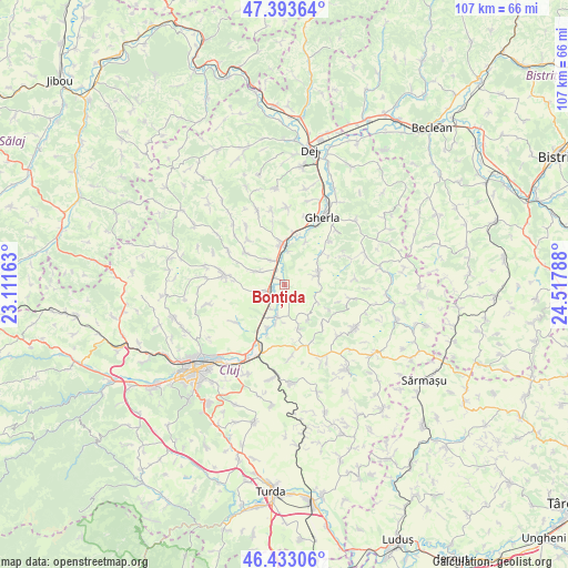
Bonțida GPS coordinates[2]
46° 54' 55.8" North, 23° 48' 53.1" East
| Map corner | latitude | longitude |
|---|---|---|
| Upper-left | 47.39364°, | 23.11163° |
| Center: | 46.9155°, | 23.81475° |
| Lower-right: | 46.43306°, | 24.51788° |
| Map W x H: | 106.8×106.8 km | = 66.4×66.4mi |
| max Lat: | 48.23793° ⇑23.3% North |
| Bonțida: | 46.9155° |
| min Lat: | ⇓76.7% South 43.65638° |
| min Long | Bonțida | max Long |
| 20.31667° | 23.81475° | 29.65403° |
| W 27.6%⇐ | ⇒72.4% E |
Elevation
Elevation of Bonțida is 276 m = 906 ft, and this is 21.1 m = 69 ft above average elevation for this country.
| Max E: |
1278 m = 4193 ft | 37.7% |
| Bonțida | 276 m 906 ft | |
| Avg. | 254.9 m = 836 ft | |
Min E: |
-2 m = -7 ft | 62.3% |
See also: Romania elevation on elevation.city.
Geographical zone
Bonțida is located in North temperate zone (between Tropic of Cancer and the Arctic Circle). Distance of this North polar circle is 2184.7 km =1357.5 mi to North.| Distance of | km | miles | from Bonțida |
|---|---|---|---|
| North Pole | 4790.5 | 2976.7 | to North |
| Arctic Circle | 2184.7 | 1357.5 | to North |
| Tropic Cancer | 2610.6 | 1622.2 | to South |
| Equator | 5216.5 | 3241.4 | to South |


Nearby cities:
15 places around Bonțida: (largest is in red/bold)
• Apahida
12 km =7.5 mi,  204°
204°
• Borşa
11.4 km =7.1 mi,  279°
279°
• Corpadea
13.8 km =8.6 mi,  175°
175°
• Dăbâca
13.5 km =8.4 mi,  303°
303°
• Fundătura
5.2 km =3.2 mi,  330°
330°
• Ghirolt
13.9 km =8.6 mi,  350°
350°
• Gădălin
8.7 km =5.4 mi,  163°
163°
• Iclod
7.6 km =4.7 mi, 351°
• Jucu de Mijloc
8.7 km =5.4 mi, 200°
• Livada
9.9 km =6.2 mi,  13°
13°
• Luna de Jos
4.8 km =3 mi, 299°
• Răscruci
3.7 km =2.3 mi,  252°
252°
• Sic
5.6 km =3.5 mi,  69°
69°
• Vaida-Cămăraș
14 km =8.7 mi,  133°
133°
• Vișea
7.9 km =4.9 mi,  145°
145°
Sources, notices
• [Note1] Compared only with cities in Romania existing in our database
• [Src1] Map data: © OpenStreetMap contributors (CC-BY-SA)
• [Src2] Other city data from geonames.org with taken over terms of usage.
• [Src3] Geographical zone / Annual Mean Temperature by Robert A. Rohde @ Wikipedia
