Apahida geodata
Apahida (Cluj) is a seat of a second-order administrative division; located in Romania in Europe/Bucharest (GMT+3) time zone. With population of 8,658 people, there are 267 cities with bigger population in this country. Compared to other cities in Romania, 74.5% of cities are located further ↓South; 73.4% of cities are located further →East and 66.4% of cities have lower elevation than Apahida. Note1


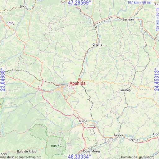
Apahida GPS coordinates[2]
46° 49' 0.012" North, 23° 45' 0" East
| Map corner | latitude | longitude |
|---|---|---|
| Upper-left | 47.29569°, | 23.04688° |
| Center: | 46.81667°, | 23.75° |
| Lower-right: | 46.33334°, | 24.45313° |
| Map W x H: | 107×107 km | = 66.5×66.5mi |
| max Lat: | 48.23793° ⇑25.5% North |
| Apahida: | 46.81667° |
| min Lat: | ⇓74.5% South 43.65638° |
| min Long | Apahida | max Long |
| 20.31667° | 23.75° | 29.65403° |
| W 26.6%⇐ | ⇒73.4% E |
Elevation
Elevation of Apahida is 299 m = 981 ft, and this is 44.1 m = 145 ft above average elevation for this country.
| Max E: |
1278 m = 4193 ft | 33.6% |
| Apahida | 299 m 981 ft | |
| Avg. | 254.9 m = 836 ft | |
Min E: |
-2 m = -7 ft | 66.4% |
See also: Romania elevation on elevation.city.
Geographical zone
Apahida is located in North temperate zone (between Tropic of Cancer and the Arctic Circle). Distance of this North polar circle is 2195.6 km =1364.3 mi to North.| Distance of | km | miles | from Apahida |
|---|---|---|---|
| North Pole | 4801.5 | 2983.5 | to North |
| Arctic Circle | 2195.6 | 1364.3 | to North |
| Tropic Cancer | 2599.6 | 1615.3 | to South |
| Equator | 5205.5 | 3234.5 | to South |


Nearby cities:
15 places around Apahida: (largest is in red/bold)
• Boju
12.1 km =7.5 mi,  168°
168°
• Bonțida
12 km =7.5 mi,  24°
24°
• Cara
7.2 km =4.5 mi,  161°
161°
• Cluj-Napoca
12.7 km =7.9 mi,  244°
244°
• Cojocna
9.8 km =6.1 mi,  139°
139°
• Corpadea
6.5 km =4 mi,  114°
114°
• Căianu Mic
13.2 km =8.2 mi, 106°
• Dezmir
6.1 km =3.8 mi,  198°
198°
• Gheorghieni
12.3 km =7.6 mi, 202°
• Gădălin
7.9 km =4.9 mi,  70°
70°
• Jucu de Mijloc
3.4 km =2.1 mi,  32°
32°
• Pata
10 km =6.2 mi,  181°
181°
• Răscruci
10 km =6.2 mi,  8°
8°
• Sânnicoară
3.5 km =2.2 mi,  211°
211°
• Vișea
10.4 km =6.5 mi,  64°
64°
Sources, notices
• [Note1] Compared only with cities in Romania existing in our database
• [Src1] Map data: © OpenStreetMap contributors (CC-BY-SA)
• [Src2] Other city data from geonames.org with taken over terms of usage.
• [Src3] Geographical zone / Annual Mean Temperature by Robert A. Rohde @ Wikipedia
