Zorlești geodata
Zorlești (Gorj) is a populated place; located in Romania in Europe/Bucharest (GMT+3) time zone. With population of 558 people, there are 6520 cities with bigger population in this country. Compared to other cities in Romania, 65.8% of cities are located further ↑North; 73.9% of cities are located further →East and 71.7% of cities have lower elevation than Zorlești. Note1


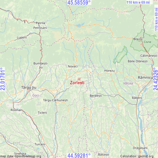
Zorlești GPS coordinates[2]
45° 5' 28.896" North, 23° 43' 12.468" East
| Map corner | latitude | longitude |
|---|---|---|
| Upper-left | 45.58559°, | 23.01701° |
| Center: | 45.09136°, | 23.72013° |
| Lower-right: | 44.59281°, | 24.42326° |
| Map W x H: | 110.4×110.4 km | = 68.6×68.6mi |
| max Lat: | 48.23793° ⇑65.8% North |
| Zorlești: | 45.09136° |
| min Lat: | ⇓34.2% South 43.65638° |
| min Long | Zorlești | max Long |
| 20.31667° | 23.72013° | 29.65403° |
| W 26.1%⇐ | ⇒73.9% E |
Elevation
Elevation of Zorlești is 332 m = 1089 ft, and this is 77.1 m = 253 ft above average elevation for this country.
| Max E: |
1278 m = 4193 ft | 28.3% |
| Zorlești | 332 m 1089 ft | |
| Avg. | 254.9 m = 836 ft | |
Min E: |
-2 m = -7 ft | 71.7% |
See also: Romania elevation on elevation.city.
Geographical zone
Zorlești is located in North temperate zone (between Tropic of Cancer and the Arctic Circle). Distance of this North polar circle is 2387.5 km =1483.5 mi to North.| Distance of | km | miles | from Zorlești |
|---|---|---|---|
| North Pole | 4993.4 | 3102.8 | to North |
| Arctic Circle | 2387.5 | 1483.5 | to North |
| Tropic Cancer | 2407.8 | 1496.1 | to South |
| Equator | 5013.7 | 3115.4 | to South |


Nearby cities:
15 places around Zorlești: (largest is in red/bold)
• Alimpeşti
6.3 km =3.9 mi,  98°
98°
• Baia de Fier
9.1 km =5.7 mi,  23°
23°
• Bucșana
3.1 km =1.9 mi,  188°
188°
• Bumbești-Pițic
4.9 km =3 mi,  327°
327°
• Bălcești
7 km =4.3 mi,  282°
282°
• Ciocadia
9.1 km =5.7 mi,  288°
288°
• Cârligei
3 km =1.9 mi,  300°
300°
• Călugăreasa
8.3 km =5.2 mi,  228°
228°
• Igoiu
8.4 km =5.2 mi,  124°
124°
• Pociovaliștea
9.1 km =5.7 mi,  318°
318°
• Poienari
5.4 km =3.4 mi,  14°
14°
• Prigoria
4 km =2.5 mi, 226°
• Roşia de Amaradia
5.2 km =3.2 mi,  152°
152°
• Seciurile
7.9 km =4.9 mi,  172°
172°
• Sârbești
5.7 km =3.5 mi,  60°
60°
Sources, notices
• [Note1] Compared only with cities in Romania existing in our database
• [Src1] Map data: © OpenStreetMap contributors (CC-BY-SA)
• [Src2] Other city data from geonames.org with taken over terms of usage.
• [Src3] Geographical zone / Annual Mean Temperature by Robert A. Rohde @ Wikipedia
