Călugăreasa geodata
Călugăreasa (Gorj) is a populated place; located in Romania in Europe/Bucharest (GMT+3) time zone. With population of 688 people, there are 5645 cities with bigger population in this country. Compared to other cities in Romania, 68% of cities are located further ↑North; 75% of cities are located further →East and 62.5% of cities have lower elevation than Călugăreasa. Note1


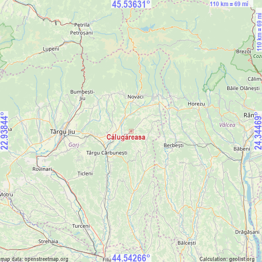
Călugăreasa GPS coordinates[2]
45° 2' 29.904" North, 23° 38' 29.616" East
| Map corner | latitude | longitude |
|---|---|---|
| Upper-left | 45.53631°, | 22.93844° |
| Center: | 45.04164°, | 23.64156° |
| Lower-right: | 44.54266°, | 24.34469° |
| Map W x H: | 110.5×110.5 km | = 68.7×68.7mi |
| max Lat: | 48.23793° ⇑68% North |
| Călugăreasa: | 45.04164° |
| min Lat: | ⇓32% South 43.65638° |
| min Long | Călugăreasa | max Long |
| 20.31667° | 23.64156° | 29.65403° |
| W 25%⇐ | ⇒75% E |
Elevation
Elevation of Călugăreasa is 277 m = 909 ft, and this is 22.1 m = 73 ft above average elevation for this country.
| Max E: |
1278 m = 4193 ft | 37.5% |
| Călugăreasa | 277 m 909 ft | |
| Avg. | 254.9 m = 836 ft | |
Min E: |
-2 m = -7 ft | 62.5% |
See also: Romania elevation on elevation.city.
Geographical zone
Călugăreasa is located in North temperate zone (between Tropic of Cancer and the Arctic Circle). Distance of this North polar circle is 2393 km =1486.9 mi to North.| Distance of | km | miles | from Călugăreasa |
|---|---|---|---|
| North Pole | 4998.9 | 3106.2 | to North |
| Arctic Circle | 2393 | 1486.9 | to North |
| Tropic Cancer | 2402.2 | 1492.7 | to South |
| Equator | 5008.2 | 3112 | to South |


Nearby cities:
15 places around Călugăreasa: (largest is in red/bold)
• Albeni
3.4 km =2.1 mi,  254°
254°
• Bengești
4.3 km =2.7 mi,  310°
310°
• Bolbocești
5.3 km =3.3 mi,  222°
222°
• Bucșana
6.2 km =3.9 mi,  66°
66°
• Bumbești-Pițic
10.3 km =6.4 mi,  20°
20°
• Bălcești
7.1 km =4.4 mi,  354°
354°
• Ciocadia
8.8 km =5.5 mi,  343°
343°
• Cârligei
7.9 km =4.9 mi,  26°
26°
• Lihulești
6.4 km =4 mi,  167°
167°
• Poiana Seciuri
8.6 km =5.3 mi,  130°
130°
• Prigoria
4.3 km =2.7 mi,  49°
49°
• Roşia de Amaradia
8.6 km =5.3 mi,  83°
83°
• Seciurile
7.5 km =4.7 mi,  107°
107°
• Zorlești
8.3 km =5.2 mi, 48°
• Ștefănești
9 km =5.6 mi, 221°
Sources, notices
• [Note1] Compared only with cities in Romania existing in our database
• [Src1] Map data: © OpenStreetMap contributors (CC-BY-SA)
• [Src2] Other city data from geonames.org with taken over terms of usage.
• [Src3] Geographical zone / Annual Mean Temperature by Robert A. Rohde @ Wikipedia
