Zărand geodata
Zărand (Arad) is a seat of a second-order administrative division; located in Romania in Europe/Bucharest (GMT+3) time zone. With population of 2,629 people, there are 2038 cities with bigger population in this country. Compared to other cities in Romania, 64.5% of cities are located further ↓South; 96.8% of cities are located further →East and 78% of cities have higher elevation than Zărand. Note1


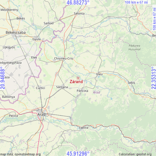
Zărand GPS coordinates[2]
46° 24' 0" North, 21° 39' 0" East
| Map corner | latitude | longitude |
|---|---|---|
| Upper-left | 46.88273°, | 20.94688° |
| Center: | 46.4°, | 21.65° |
| Lower-right: | 45.91296°, | 22.35313° |
| Map W x H: | 107.8×107.8 km | = 67×67mi |
| max Lat: | 48.23793° ⇑35.5% North |
| Zărand: | 46.4° |
| min Lat: | ⇓64.5% South 43.65638° |
| min Long | Zărand | max Long |
| 20.31667° | 21.65° | 29.65403° |
| W 3.2%⇐ | ⇒96.8% E |
Elevation
Elevation of Zărand is 101 m = 331 ft, and this is 153.9 m = 505 ft below average elevation for this country.
| Max E: |
1278 m = 4193 ft | 78% |
| Avg. | 254.9 m = 836 ft | |
| Zărand | 101 m = 331 ft | |
Min E: |
-2 m = -7 ft | 22% |
See also: Romania elevation on elevation.city.
Geographical zone
Zărand is located in North temperate zone (between Tropic of Cancer and the Arctic Circle). Distance of this North polar circle is 2242 km =1393.1 mi to North.| Distance of | km | miles | from Zărand |
|---|---|---|---|
| North Pole | 4847.9 | 3012.3 | to North |
| Arctic Circle | 2242 | 1393.1 | to North |
| Tropic Cancer | 2553.3 | 1586.5 | to South |
| Equator | 5159.2 | 3205.8 | to South |


Nearby cities:
15 places around Zărand: (largest is in red/bold)
• Caporal Alexa
8.6 km =5.3 mi,  216°
216°
• Chereluș
8.8 km =5.5 mi,  29°
29°
• Cintei
8.1 km =5 mi,  307°
307°
• Galșa
12.4 km =7.7 mi,  179°
179°
• Gurba
13 km =8.1 mi,  54°
54°
• Mocrea
13.3 km =8.3 mi,  95°
95°
• Moroda
9.4 km =5.8 mi,  110°
110°
• Mâsca
11.4 km =7.1 mi,  167°
167°
• Măderat
12.6 km =7.8 mi,  158°
158°
• Olari
7.9 km =4.9 mi,  256°
256°
• Pâncota
8.3 km =5.2 mi,  152°
152°
• Seleuş
5.4 km =3.4 mi, 109°
• Sântana
12.8 km =8 mi,  244°
244°
• Şicula
8.5 km =5.3 mi,  64°
64°
• Țipar
8.5 km =5.3 mi,  351°
351°
Sources, notices
• [Note1] Compared only with cities in Romania existing in our database
• [Src1] Map data: © OpenStreetMap contributors (CC-BY-SA)
• [Src2] Other city data from geonames.org with taken over terms of usage.
• [Src3] Geographical zone / Annual Mean Temperature by Robert A. Rohde @ Wikipedia
