Pâncota geodata
Pâncota (Arad) is a seat of a second-order administrative division; located in Romania in Europe/Bucharest (GMT+3) time zone. With population of 7,133 people, there are 388 cities with bigger population in this country. Compared to other cities in Romania, 62.9% of cities are located further ↓South; 96.5% of cities are located further →East and 76.7% of cities have higher elevation than Pâncota. Note1


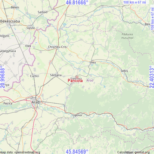
Pâncota GPS coordinates[2]
46° 19' 59.988" North, 21° 42' 0" East
| Map corner | latitude | longitude |
|---|---|---|
| Upper-left | 46.81666°, | 20.99688° |
| Center: | 46.33333°, | 21.7° |
| Lower-right: | 45.84569°, | 22.40313° |
| Map W x H: | 108×108 km | = 67.1×67.1mi |
| max Lat: | 48.23793° ⇑37.1% North |
| Pâncota: | 46.33333° |
| min Lat: | ⇓62.9% South 43.65638° |
| min Long | Pâncota | max Long |
| 20.31667° | 21.7° | 29.65403° |
| W 3.5%⇐ | ⇒96.5% E |
Elevation
Elevation of Pâncota is 105 m = 344 ft, and this is 149.9 m = 492 ft below average elevation for this country.
| Max E: |
1278 m = 4193 ft | 76.7% |
| Avg. | 254.9 m = 836 ft | |
| Pâncota | 105 m = 344 ft | |
Min E: |
-2 m = -7 ft | 23.3% |
See also: Romania elevation on elevation.city.
Geographical zone
Pâncota is located in North temperate zone (between Tropic of Cancer and the Arctic Circle). Distance of this North polar circle is 2249.4 km =1397.7 mi to North.| Distance of | km | miles | from Pâncota |
|---|---|---|---|
| North Pole | 4855.3 | 3016.9 | to North |
| Arctic Circle | 2249.4 | 1397.7 | to North |
| Tropic Cancer | 2545.9 | 1581.9 | to South |
| Equator | 5151.8 | 3201.2 | to South |


Nearby cities:
15 places around Pâncota: (largest is in red/bold)
• Agrișu Mare
8 km =5 mi,  147°
147°
• Caporal Alexa
9 km =5.6 mi,  273°
273°
• Chier
9.6 km =6 mi,  84°
84°
• Drauț
11.7 km =7.3 mi,  133°
133°
• Dud
12.7 km =7.9 mi,  107°
107°
• Galșa
6.3 km =3.9 mi,  216°
216°
• Mocrea
11.2 km =7 mi,  57°
57°
• Moroda
6.4 km =4 mi,  50°
50°
• Mâsca
3.9 km =2.4 mi,  199°
199°
• Măderat
4.4 km =2.7 mi,  168°
168°
• Seleuş
5.7 km =3.5 mi,  12°
12°
• Târnova
7.9 km =4.9 mi,  103°
103°
• Zărand
8.3 km =5.2 mi,  332°
332°
• Şicula
11.8 km =7.3 mi,  19°
19°
• Şiria
9 km =5.6 mi,  214°
214°
Sources, notices
• [Note1] Compared only with cities in Romania existing in our database
• [Src1] Map data: © OpenStreetMap contributors (CC-BY-SA)
• [Src2] Other city data from geonames.org with taken over terms of usage.
• [Src3] Geographical zone / Annual Mean Temperature by Robert A. Rohde @ Wikipedia
