Seleuş geodata
Seleuş (Arad) is a seat of a second-order administrative division; located in Romania in Europe/Bucharest (GMT+3) time zone. With population of 3,140 people, there are 1662 cities with bigger population in this country. Compared to other cities in Romania, 64.1% of cities are located further ↓South; 96.4% of cities are located further →East and 77.4% of cities have higher elevation than Seleuş. Note1


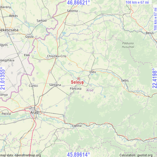
Seleuş GPS coordinates[2]
46° 22' 59.988" North, 21° 43' 0.012" East
| Map corner | latitude | longitude |
|---|---|---|
| Upper-left | 46.86621°, | 21.01355° |
| Center: | 46.38333°, | 21.71667° |
| Lower-right: | 45.89614°, | 22.4198° |
| Map W x H: | 107.9×107.9 km | = 67×67mi |
| max Lat: | 48.23793° ⇑35.9% North |
| Seleuş: | 46.38333° |
| min Lat: | ⇓64.1% South 43.65638° |
| min Long | Seleuş | max Long |
| 20.31667° | 21.71667° | 29.65403° |
| W 3.6%⇐ | ⇒96.4% E |
Elevation
Elevation of Seleuş is 103 m = 338 ft, and this is 151.9 m = 498 ft below average elevation for this country.
| Max E: |
1278 m = 4193 ft | 77.4% |
| Avg. | 254.9 m = 836 ft | |
| Seleuş | 103 m = 338 ft | |
Min E: |
-2 m = -7 ft | 22.6% |
See also: Romania elevation on elevation.city.
Geographical zone
Seleuş is located in North temperate zone (between Tropic of Cancer and the Arctic Circle). Distance of this North polar circle is 2243.8 km =1394.2 mi to North.| Distance of | km | miles | from Seleuş |
|---|---|---|---|
| North Pole | 4849.7 | 3013.5 | to North |
| Arctic Circle | 2243.8 | 1394.2 | to North |
| Tropic Cancer | 2551.4 | 1585.4 | to South |
| Equator | 5157.3 | 3204.6 | to South |


Nearby cities:
15 places around Seleuş: (largest is in red/bold)
• Caporal Alexa
11.4 km =7.1 mi,  243°
243°
• Chereluș
9.5 km =5.9 mi,  355°
355°
• Chier
9.5 km =5.9 mi,  118°
118°
• Galșa
11.7 km =7.3 mi,  205°
205°
• Gurba
10.8 km =6.7 mi,  30°
30°
• Ineu
11 km =6.8 mi,  59°
59°
• Mocrea
8.1 km =5 mi,  86°
86°
• Moroda
3.9 km =2.4 mi,  111°
111°
• Mâsca
9.6 km =6 mi,  195°
195°
• Măderat
9.8 km =6.1 mi,  182°
182°
• Pâncota
5.7 km =3.5 mi,  192°
192°
• Târnova
9.8 km =6.1 mi,  139°
139°
• Zărand
5.4 km =3.4 mi,  289°
289°
• Şicula
6.1 km =3.8 mi,  24°
24°
• Țipar
12 km =7.5 mi,  328°
328°
Sources, notices
• [Note1] Compared only with cities in Romania existing in our database
• [Src1] Map data: © OpenStreetMap contributors (CC-BY-SA)
• [Src2] Other city data from geonames.org with taken over terms of usage.
• [Src3] Geographical zone / Annual Mean Temperature by Robert A. Rohde @ Wikipedia
