Vlahii geodata
Vlahii (Constanța) is a populated place; located in Romania in Europe/Bucharest (GMT+3) time zone. With population of 572 people, there are 6412 cities with bigger population in this country. Compared to other cities in Romania, 93.2% of cities are located further ↑North; 95% of cities are located further ←West and 96.2% of cities have higher elevation than Vlahii. Note1


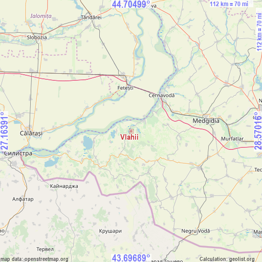
Vlahii GPS coordinates[2]
44° 12' 11.16" North, 27° 52' 1.308" East
| Map corner | latitude | longitude |
|---|---|---|
| Upper-left | 44.70499°, | 27.16391° |
| Center: | 44.2031°, | 27.86703° |
| Lower-right: | 43.69689°, | 28.57016° |
| Map W x H: | 112.1×112.1 km | = 69.7×69.7mi |
| max Lat: | 48.23793° ⇑93.2% North |
| Vlahii: | 44.2031° |
| min Lat: | ⇓6.8% South 43.65638° |
| min Long | Vlahii | max Long |
| 20.31667° | 27.86703° | 29.65403° |
| W 95%⇐ | ⇒5% E |
Elevation
Elevation of Vlahii is 28 m = 92 ft, and this is 226.9 m = 744 ft below average elevation for this country.
| Max E: |
1278 m = 4193 ft | 96.2% |
| Avg. | 254.9 m = 836 ft | |
| Vlahii | 28 m = 92 ft | |
Min E: |
-2 m = -7 ft | 3.8% |
See also: Romania elevation on elevation.city.
Geographical zone
Vlahii is located in North temperate zone (between Tropic of Cancer and the Arctic Circle). Distance of this Northern Tropic circle is 2309 km =1434.7 mi to South.| Distance of | km | miles | from Vlahii |
|---|---|---|---|
| North Pole | 5092.1 | 3164.1 | to North |
| Arctic Circle | 2486.3 | 1544.9 | to North |
| Tropic Cancer | 2309 | 1434.7 | to South |
| Equator | 4914.9 | 3054 | to South |


Nearby cities:
15 places around Vlahii: (largest is in red/bold)
• Adamclisi
14.9 km =9.3 mi,  153°
153°
• Aliman
2.6 km =1.6 mi,  211°
211°
• Borcea
17.2 km =10.7 mi,  327°
327°
• Buliga
18.2 km =11.3 mi,  340°
340°
• Deleni
16.6 km =10.3 mi,  133°
133°
• Dunăreni
6.1 km =3.8 mi,  271°
271°
• Ion Corvin
11 km =6.8 mi, 209°
• Ivrinezu Mare
16.1 km =10 mi,  79°
79°
• Negureni
15 km =9.3 mi,  216°
216°
• Oltina
16.5 km =10.3 mi,  255°
255°
• Rasova
7.2 km =4.5 mi,  48°
48°
• Răzoarele
18.7 km =11.6 mi,  232°
232°
• Viile
9.8 km =6.1 mi,  242°
242°
• Zorile
15.2 km =9.4 mi,  159°
159°
• Șipotele
19.1 km =11.9 mi, 157°
Sources, notices
• [Note1] Compared only with cities in Romania existing in our database
• [Src1] Map data: © OpenStreetMap contributors (CC-BY-SA)
• [Src2] Other city data from geonames.org with taken over terms of usage.
• [Src3] Geographical zone / Annual Mean Temperature by Robert A. Rohde @ Wikipedia
