Răzoarele geodata
Răzoarele (Constanța) is a populated place; located in Romania in Europe/Bucharest (GMT+3) time zone. With population of 646 people, there are 5901 cities with bigger population in this country. Compared to other cities in Romania, 95.3% of cities are located further ↑North; 93% of cities are located further ←West and 77.4% of cities have higher elevation than Răzoarele. Note1


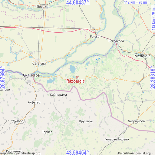
Răzoarele GPS coordinates[2]
44° 6' 5.796" North, 27° 40' 48.216" East
| Map corner | latitude | longitude |
|---|---|---|
| Upper-left | 44.60437°, | 26.97694° |
| Center: | 44.10161°, | 27.68006° |
| Lower-right: | 43.59454°, | 28.38319° |
| Map W x H: | 112.3×112.3 km | = 69.8×69.8mi |
| max Lat: | 48.23793° ⇑95.3% North |
| Răzoarele: | 44.10161° |
| min Lat: | ⇓4.7% South 43.65638° |
| min Long | Răzoarele | max Long |
| 20.31667° | 27.68006° | 29.65403° |
| W 93%⇐ | ⇒7% E |
Elevation
Elevation of Răzoarele is 103 m = 338 ft, and this is 151.9 m = 498 ft below average elevation for this country.
| Max E: |
1278 m = 4193 ft | 77.4% |
| Avg. | 254.9 m = 836 ft | |
| Răzoarele | 103 m = 338 ft | |
Min E: |
-2 m = -7 ft | 22.6% |
See also: Romania elevation on elevation.city.
Geographical zone
Răzoarele is located in North temperate zone (between Tropic of Cancer and the Arctic Circle). Distance of this Northern Tropic circle is 2297.7 km =1427.7 mi to South.| Distance of | km | miles | from Răzoarele |
|---|---|---|---|
| North Pole | 5103.4 | 3171.1 | to North |
| Arctic Circle | 2497.5 | 1551.9 | to North |
| Tropic Cancer | 2297.7 | 1427.7 | to South |
| Equator | 4903.6 | 3047 | to South |


Nearby cities:
15 places around Răzoarele: (largest is in red/bold)
• Aliman
16.3 km =10.1 mi,  56°
56°
• Băneasa
4.2 km =2.6 mi,  157°
157°
• Canlia
12.3 km =7.6 mi,  282°
282°
• Carvăn
11.4 km =7.1 mi,  231°
231°
• Coslugea
8.3 km =5.2 mi, 283°
• Dobromir
12.5 km =7.8 mi,  138°
138°
• Dunăreni
14.5 km =9 mi,  37°
37°
• Făurei
6.9 km =4.3 mi,  167°
167°
• Galița
15.1 km =9.4 mi,  269°
269°
• Ion Corvin
9.7 km =6 mi,  80°
80°
• Lipniţa
6.4 km =4 mi, 268°
• Negureni
5.9 km =3.7 mi,  97°
97°
• Oltina
7.3 km =4.5 mi,  351°
351°
• Satnoeni
17.9 km =11.1 mi,  324°
324°
• Viile
9.1 km =5.7 mi, 42°
Sources, notices
• [Note1] Compared only with cities in Romania existing in our database
• [Src1] Map data: © OpenStreetMap contributors (CC-BY-SA)
• [Src2] Other city data from geonames.org with taken over terms of usage.
• [Src3] Geographical zone / Annual Mean Temperature by Robert A. Rohde @ Wikipedia
