Deleni geodata
Deleni (Constanța) is a seat of a second-order administrative division; located in Romania in Europe/Bucharest (GMT+3) time zone. With population of 2,492 people, there are 2167 cities with bigger population in this country. Compared to other cities in Romania, 95.5% of cities are located further ↑North; 96.4% of cities are located further ←West and 72.7% of cities have higher elevation than Deleni. Note1


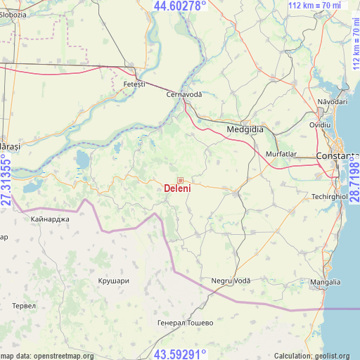
Deleni GPS coordinates[2]
44° 6' 0" North, 28° 1' 0.012" East
| Map corner | latitude | longitude |
|---|---|---|
| Upper-left | 44.60278°, | 27.31355° |
| Center: | 44.1°, | 28.01667° |
| Lower-right: | 43.59291°, | 28.7198° |
| Map W x H: | 112.3×112.3 km | = 69.8×69.8mi |
| max Lat: | 48.23793° ⇑95.5% North |
| Deleni: | 44.1° |
| min Lat: | ⇓4.5% South 43.65638° |
| min Long | Deleni | max Long |
| 20.31667° | 28.01667° | 29.65403° |
| W 96.4%⇐ | ⇒3.6% E |
Elevation
Elevation of Deleni is 118 m = 387 ft, and this is 136.9 m = 449 ft below average elevation for this country.
| Max E: |
1278 m = 4193 ft | 72.7% |
| Avg. | 254.9 m = 836 ft | |
| Deleni | 118 m = 387 ft | |
Min E: |
-2 m = -7 ft | 27.3% |
See also: Romania elevation on elevation.city.
Geographical zone
Deleni is located in North temperate zone (between Tropic of Cancer and the Arctic Circle). Distance of this Northern Tropic circle is 2297.5 km =1427.6 mi to South.| Distance of | km | miles | from Deleni |
|---|---|---|---|
| North Pole | 5103.6 | 3171.2 | to North |
| Arctic Circle | 2497.7 | 1552 | to North |
| Tropic Cancer | 2297.5 | 1427.6 | to South |
| Equator | 4903.5 | 3046.9 | to South |


Nearby cities:
15 places around Deleni: (largest is in red/bold)
• Adamclisi
5.6 km =3.5 mi,  250°
250°
• Aliman
16.2 km =10.1 mi,  304°
304°
• Cobadin
16.1 km =10 mi,  96°
96°
• Independenţa
15.8 km =9.8 mi,  160°
160°
• Ion Corvin
17.4 km =10.8 mi,  276°
276°
• Ivrinezu Mare
14.9 km =9.3 mi,  15°
15°
• Negrești
14.5 km =9 mi,  140°
140°
• Petroșani
9.9 km =6.2 mi, 163°
• Peştera
13.1 km =8.1 mi,  45°
45°
• Pietreni
4.1 km =2.5 mi, 96°
• Rasova
17.5 km =10.9 mi,  338°
338°
• Viișoara
14.4 km =8.9 mi, 99°
• Vlahii
16.6 km =10.3 mi,  313°
313°
• Zorile
7.1 km =4.4 mi, 247°
• Șipotele
7.6 km =4.7 mi,  216°
216°
Sources, notices
• [Note1] Compared only with cities in Romania existing in our database
• [Src1] Map data: © OpenStreetMap contributors (CC-BY-SA)
• [Src2] Other city data from geonames.org with taken over terms of usage.
• [Src3] Geographical zone / Annual Mean Temperature by Robert A. Rohde @ Wikipedia
