Vişineşti geodata
Vişineşti (Dâmboviţa) is a seat of a second-order administrative division; located in Romania in Europe/Bucharest (GMT+3) time zone. With population of 2,372 people, there are 2259 cities with bigger population in this country. Compared to other cities in Romania, 65.6% of cities are located further ↑North; 55.2% of cities are located further ←West and 88.7% of cities have lower elevation than Vişineşti. Note1


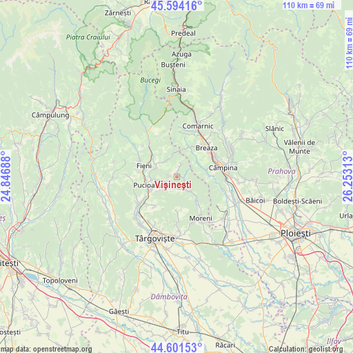
Vişineşti GPS coordinates[2]
45° 6' 0" North, 25° 33' 0" East
| Map corner | latitude | longitude |
|---|---|---|
| Upper-left | 45.59416°, | 24.84688° |
| Center: | 45.1°, | 25.55° |
| Lower-right: | 44.60153°, | 26.25313° |
| Map W x H: | 110.4×110.4 km | = 68.6×68.6mi |
| max Lat: | 48.23793° ⇑65.6% North |
| Vişineşti: | 45.1° |
| min Lat: | ⇓34.4% South 43.65638° |
| min Long | Vişineşti | max Long |
| 20.31667° | 25.55° | 29.65403° |
| W 55.2%⇐ | ⇒44.8% E |
Elevation
Elevation of Vişineşti is 493 m = 1617 ft, and this is 238.1 m = 781 ft above average elevation for this country.
| Max E: |
1278 m = 4193 ft | 11.3% |
| Vişineşti | 493 m 1617 ft | |
| Avg. | 254.9 m = 836 ft | |
Min E: |
-2 m = -7 ft | 88.7% |
See also: Romania elevation on elevation.city.
Geographical zone
Vişineşti is located in North temperate zone (between Tropic of Cancer and the Arctic Circle). Distance of this North polar circle is 2386.5 km =1482.9 mi to North.| Distance of | km | miles | from Vişineşti |
|---|---|---|---|
| North Pole | 4992.4 | 3102.1 | to North |
| Arctic Circle | 2386.5 | 1482.9 | to North |
| Tropic Cancer | 2408.7 | 1496.7 | to South |
| Equator | 5014.6 | 3115.9 | to South |


Nearby cities:
15 places around Vişineşti: (largest is in red/bold)
• Adunaţi
6.4 km =4 mi,  54°
54°
• Bezdead
6.1 km =3.8 mi,  334°
334°
• Diaconești
7.6 km =4.7 mi,  264°
264°
• Izvoru
2.9 km =1.8 mi,  204°
204°
• Măgura
6.8 km =4.2 mi,  296°
296°
• Proviţa de Jos
8.1 km =5 mi,  76°
76°
• Proviţa de Sus
7.5 km =4.7 mi,  60°
60°
• Urseiu
3.3 km =2.1 mi,  17°
17°
• Valea Leurzii
8.5 km =5.3 mi,  323°
323°
• Valea Lungă Gorgota
4 km =2.5 mi,  169°
169°
• Valea Lungă Ogrea
5.5 km =3.4 mi,  144°
144°
• Valea Lungă-Cricov
4.9 km =3 mi, 142°
• Valea Mare
6.5 km =4 mi,  134°
134°
• Vârfuri
2.6 km =1.6 mi,  270°
270°
• Ștubeie Tisa
4.4 km =2.7 mi,  213°
213°
Sources, notices
• [Note1] Compared only with cities in Romania existing in our database
• [Src1] Map data: © OpenStreetMap contributors (CC-BY-SA)
• [Src2] Other city data from geonames.org with taken over terms of usage.
• [Src3] Geographical zone / Annual Mean Temperature by Robert A. Rohde @ Wikipedia
