Vârfuri geodata
Vârfuri (Dâmboviţa) is a seat of a second-order administrative division; located in Romania in Europe/Bucharest (GMT+3) time zone. With population of 2,086 people, there are 2528 cities with bigger population in this country. Compared to other cities in Romania, 65.6% of cities are located further ↑North; 54.7% of cities are located further ←West and 90% of cities have lower elevation than Vârfuri. Note1


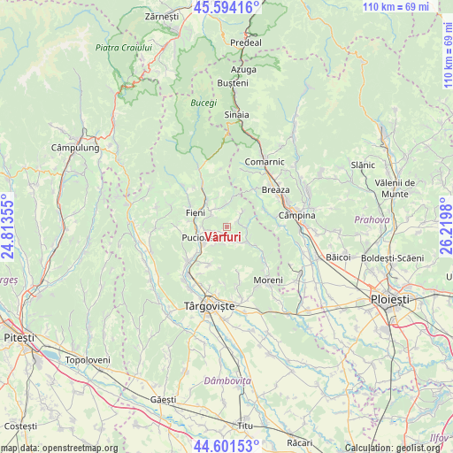
Vârfuri GPS coordinates[2]
45° 6' 0" North, 25° 31' 0.012" East
| Map corner | latitude | longitude |
|---|---|---|
| Upper-left | 45.59416°, | 24.81355° |
| Center: | 45.1°, | 25.51667° |
| Lower-right: | 44.60153°, | 26.2198° |
| Map W x H: | 110.4×110.4 km | = 68.6×68.6mi |
| max Lat: | 48.23793° ⇑65.6% North |
| Vârfuri: | 45.1° |
| min Lat: | ⇓34.4% South 43.65638° |
| min Long | Vârfuri | max Long |
| 20.31667° | 25.51667° | 29.65403° |
| W 54.7%⇐ | ⇒45.3% E |
Elevation
Elevation of Vârfuri is 512 m = 1680 ft, and this is 257.1 m = 844 ft above average elevation for this country.
| Max E: |
1278 m = 4193 ft | 10% |
| Vârfuri | 512 m 1680 ft | |
| Avg. | 254.9 m = 836 ft | |
Min E: |
-2 m = -7 ft | 90% |
See also: Romania elevation on elevation.city.
Geographical zone
Vârfuri is located in North temperate zone (between Tropic of Cancer and the Arctic Circle). Distance of this North polar circle is 2386.5 km =1482.9 mi to North.| Distance of | km | miles | from Vârfuri |
|---|---|---|---|
| North Pole | 4992.4 | 3102.1 | to North |
| Arctic Circle | 2386.5 | 1482.9 | to North |
| Tropic Cancer | 2408.7 | 1496.7 | to South |
| Equator | 5014.6 | 3115.9 | to South |


Nearby cities:
15 places around Vârfuri: (largest is in red/bold)
• Bela
6.4 km =4 mi,  269°
269°
• Berevoești
7.6 km =4.7 mi,  284°
284°
• Bezdead
5.6 km =3.5 mi,  0°
0°
• Diaconești
5 km =3.1 mi,  260°
260°
• Glodeni
6.4 km =4 mi,  230°
230°
• Izvoru
3 km =1.9 mi,  151°
151°
• Măgura
4.6 km =2.9 mi,  310°
310°
• Pucioasa
7.1 km =4.4 mi,  249°
249°
• Urseiu
4.8 km =3 mi,  48°
48°
• Valea Leurzii
7.3 km =4.5 mi,  340°
340°
• Valea Lungă Gorgota
5.2 km =3.2 mi,  139°
139°
• Valea Lungă Ogrea
7.3 km =4.5 mi,  127°
127°
• Valea Lungă-Cricov
6.8 km =4.2 mi,  124°
124°
• Vişineşti
2.6 km =1.6 mi,  90°
90°
• Ștubeie Tisa
3.7 km =2.3 mi,  176°
176°
Sources, notices
• [Note1] Compared only with cities in Romania existing in our database
• [Src1] Map data: © OpenStreetMap contributors (CC-BY-SA)
• [Src2] Other city data from geonames.org with taken over terms of usage.
• [Src3] Geographical zone / Annual Mean Temperature by Robert A. Rohde @ Wikipedia
