Vâlcelele geodata
Vâlcelele (Buzău) is a seat of a second-order administrative division; located in Romania in Europe/Bucharest (GMT+3) time zone. With population of 1,887 people, there are 2720 cities with bigger population in this country. Compared to other cities in Romania, 57.9% of cities are located further ↑North; 88.9% of cities are located further ←West and 94.7% of cities have higher elevation than Vâlcelele. Note1


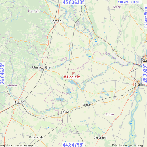
Vâlcelele GPS coordinates[2]
45° 20' 39.48" North, 27° 20' 57.732" East
| Map corner | latitude | longitude |
|---|---|---|
| Upper-left | 45.83633°, | 26.64625° |
| Center: | 45.3443°, | 27.34937° |
| Lower-right: | 44.84796°, | 28.0525° |
| Map W x H: | 109.9×109.9 km | = 68.3×68.3mi |
| max Lat: | 48.23793° ⇑57.9% North |
| Vâlcelele: | 45.3443° |
| min Lat: | ⇓42.1% South 43.65638° |
| min Long | Vâlcelele | max Long |
| 20.31667° | 27.34937° | 29.65403° |
| W 88.9%⇐ | ⇒11.1% E |
Elevation
Elevation of Vâlcelele is 36 m = 118 ft, and this is 218.9 m = 718 ft below average elevation for this country.
| Max E: |
1278 m = 4193 ft | 94.7% |
| Avg. | 254.9 m = 836 ft | |
| Vâlcelele | 36 m = 118 ft | |
Min E: |
-2 m = -7 ft | 5.3% |
See also: Romania elevation on elevation.city.
Geographical zone
Vâlcelele is located in North temperate zone (between Tropic of Cancer and the Arctic Circle). Distance of this North polar circle is 2359.4 km =1466.1 mi to North.| Distance of | km | miles | from Vâlcelele |
|---|---|---|---|
| North Pole | 4965.2 | 3085.2 | to North |
| Arctic Circle | 2359.4 | 1466.1 | to North |
| Tropic Cancer | 2435.9 | 1513.6 | to South |
| Equator | 5041.8 | 3132.8 | to South |


Nearby cities:
15 places around Vâlcelele: (largest is in red/bold)
• Amara
11.5 km =7.1 mi,  202°
202°
• Balta Albă
6.7 km =4.2 mi,  228°
228°
• Boldu
9.2 km =5.7 mi,  262°
262°
• Băile
6.1 km =3.8 mi,  170°
170°
• Ciorăşti
10.6 km =6.6 mi,  338°
338°
• Cuza Vodă
9.3 km =5.8 mi,  56°
56°
• Dăscălești
10.4 km =6.5 mi,  311°
311°
• Grădiştea
9 km =5.6 mi,  162°
162°
• Ibrianu
11 km =6.8 mi, 166°
• Mihălceni
11.7 km =7.3 mi, 342°
• Măcrina
12.7 km =7.9 mi,  291°
291°
• Nicolești
11 km =6.8 mi,  303°
303°
• Puieștii de Jos
12 km =7.5 mi, 302°
• Racoviţa
9.3 km =5.8 mi,  122°
122°
• Salcia Nouă
12.5 km =7.8 mi,  356°
356°
Sources, notices
• [Note1] Compared only with cities in Romania existing in our database
• [Src1] Map data: © OpenStreetMap contributors (CC-BY-SA)
• [Src2] Other city data from geonames.org with taken over terms of usage.
• [Src3] Geographical zone / Annual Mean Temperature by Robert A. Rohde @ Wikipedia
