Ciorăşti geodata
Ciorăşti (Vrancea) is a seat of a second-order administrative division; located in Romania in Europe/Bucharest (GMT+3) time zone. With population of 3,861 people, there are 1225 cities with bigger population in this country. Compared to other cities in Romania, 56.4% of cities are located further ↑North; 88.3% of cities are located further ←West and 94.2% of cities have higher elevation than Ciorăşti. Note1


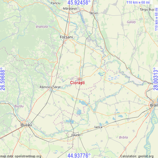
Ciorăşti GPS coordinates[2]
45° 25' 59.988" North, 27° 18' 0" East
| Map corner | latitude | longitude |
|---|---|---|
| Upper-left | 45.92458°, | 26.59688° |
| Center: | 45.43333°, | 27.3° |
| Lower-right: | 44.93776°, | 28.00313° |
| Map W x H: | 109.7×109.7 km | = 68.2×68.2mi |
| max Lat: | 48.23793° ⇑56.4% North |
| Ciorăşti: | 45.43333° |
| min Lat: | ⇓43.6% South 43.65638° |
| min Long | Ciorăşti | max Long |
| 20.31667° | 27.3° | 29.65403° |
| W 88.3%⇐ | ⇒11.7% E |
Elevation
Elevation of Ciorăşti is 38 m = 125 ft, and this is 216.9 m = 712 ft below average elevation for this country.
| Max E: |
1278 m = 4193 ft | 94.2% |
| Avg. | 254.9 m = 836 ft | |
| Ciorăşti | 38 m = 125 ft | |
Min E: |
-2 m = -7 ft | 5.8% |
See also: Romania elevation on elevation.city.
Geographical zone
Ciorăşti is located in North temperate zone (between Tropic of Cancer and the Arctic Circle). Distance of this North polar circle is 2349.5 km =1459.9 mi to North.| Distance of | km | miles | from Ciorăşti |
|---|---|---|---|
| North Pole | 4955.3 | 3079.1 | to North |
| Arctic Circle | 2349.5 | 1459.9 | to North |
| Tropic Cancer | 2445.8 | 1519.7 | to South |
| Equator | 5051.7 | 3139 | to South |


Nearby cities:
15 places around Ciorăşti: (largest is in red/bold)
• Bogza
11.5 km =7.1 mi,  316°
316°
• Boldu
12.3 km =7.6 mi,  205°
205°
• Bordeasca Veche
12.4 km =7.7 mi,  6°
6°
• Băleşti
5.2 km =3.2 mi,  270°
270°
• Dăscălești
4.9 km =3 mi,  232°
232°
• Mihălceni
1.3 km =0.8 mi,  15°
15°
• Măcrina
9.4 km =5.8 mi,  236°
236°
• Mărtinești
7.8 km =4.8 mi,  3°
3°
• Nicolești
6.6 km =4.1 mi, 234°
• Puieștii de Jos
7.1 km =4.4 mi, 241°
• Puieștii de Sus
9.3 km =5.8 mi, 243°
• Salcia Nouă
4.1 km =2.5 mi,  50°
50°
• Tătăranu
9.4 km =5.8 mi, 7°
• Voetin
12.1 km =7.5 mi,  275°
275°
• Vâlcelele
10.6 km =6.6 mi,  158°
158°
Sources, notices
• [Note1] Compared only with cities in Romania existing in our database
• [Src1] Map data: © OpenStreetMap contributors (CC-BY-SA)
• [Src2] Other city data from geonames.org with taken over terms of usage.
• [Src3] Geographical zone / Annual Mean Temperature by Robert A. Rohde @ Wikipedia
