Mihălceni geodata
Mihălceni (Vrancea) is a populated place; located in Romania in Europe/Bucharest (GMT+3) time zone. With population of 1,016 people, there are 4242 cities with bigger population in this country. Compared to other cities in Romania, 56.2% of cities are located further ↑North; 88.4% of cities are located further ←West and 93.2% of cities have higher elevation than Mihălceni. Note1


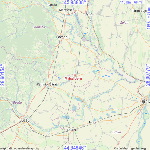
Mihălceni GPS coordinates[2]
45° 26' 41.748" North, 27° 18' 16.776" East
| Map corner | latitude | longitude |
|---|---|---|
| Upper-left | 45.93608°, | 26.60154° |
| Center: | 45.44493°, | 27.30466° |
| Lower-right: | 44.94946°, | 28.00779° |
| Map W x H: | 109.7×109.7 km | = 68.2×68.2mi |
| max Lat: | 48.23793° ⇑56.2% North |
| Mihălceni: | 45.44493° |
| min Lat: | ⇓43.8% South 43.65638° |
| min Long | Mihălceni | max Long |
| 20.31667° | 27.30466° | 29.65403° |
| W 88.4%⇐ | ⇒11.6% E |
Elevation
Elevation of Mihălceni is 42 m = 138 ft, and this is 212.9 m = 698 ft below average elevation for this country.
| Max E: |
1278 m = 4193 ft | 93.2% |
| Avg. | 254.9 m = 836 ft | |
| Mihălceni | 42 m = 138 ft | |
Min E: |
-2 m = -7 ft | 6.8% |
See also: Romania elevation on elevation.city.
Geographical zone
Mihălceni is located in North temperate zone (between Tropic of Cancer and the Arctic Circle). Distance of this North polar circle is 2348.2 km =1459.1 mi to North.| Distance of | km | miles | from Mihălceni |
|---|---|---|---|
| North Pole | 4954.1 | 3078.3 | to North |
| Arctic Circle | 2348.2 | 1459.1 | to North |
| Tropic Cancer | 2447.1 | 1520.6 | to South |
| Equator | 5053 | 3139.8 | to South |


Nearby cities:
15 places around Mihălceni: (largest is in red/bold)
• Bogza
10.9 km =6.8 mi,  310°
310°
• Bordeasca Veche
11.1 km =6.9 mi,  5°
5°
• Băleşti
5.7 km =3.5 mi,  256°
256°
• Ciorăşti
1.3 km =0.8 mi,  195°
195°
• Dăscălești
6 km =3.7 mi,  224°
224°
• Măcrina
10.5 km =6.5 mi,  231°
231°
• Mărtinești
6.5 km =4 mi,  0°
0°
• Nicolești
7.7 km =4.8 mi, 228°
• Puieștii de Jos
8.1 km =5 mi, 234°
• Puieștii de Sus
10.2 km =6.3 mi,  238°
238°
• Salcia Nouă
3.1 km =1.9 mi,  64°
64°
• Slobozia Botești
12.4 km =7.7 mi,  48°
48°
• Tătăranu
8 km =5 mi, 6°
• Voetin
12.4 km =7.7 mi,  269°
269°
• Vâlcelele
11.7 km =7.3 mi,  162°
162°
Sources, notices
• [Note1] Compared only with cities in Romania existing in our database
• [Src1] Map data: © OpenStreetMap contributors (CC-BY-SA)
• [Src2] Other city data from geonames.org with taken over terms of usage.
• [Src3] Geographical zone / Annual Mean Temperature by Robert A. Rohde @ Wikipedia
