Vâlcele geodata
Vâlcele (Bacău) is a section of populated place; located in Romania in Europe/Bucharest (GMT+3) time zone. With population of 1,272 people, there are 3582 cities with bigger population in this country. Compared to other cities in Romania, 62% of cities are located further ↓South; 74.7% of cities are located further ←West and 71% of cities have lower elevation than Vâlcele. Note1


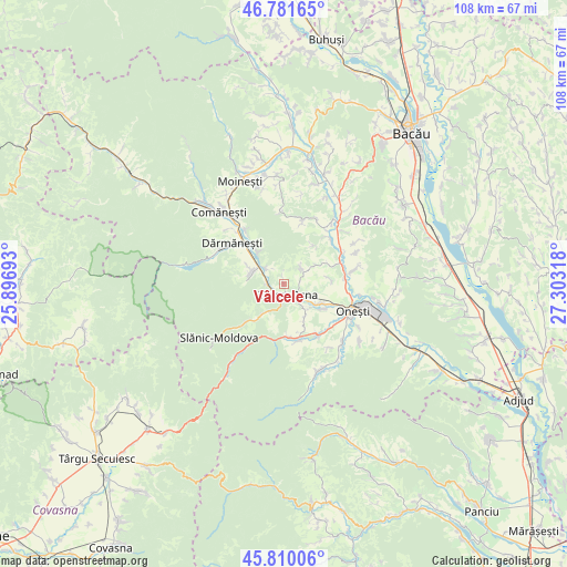
Vâlcele GPS coordinates[2]
46° 17' 52.836" North, 26° 36' 0.18" East
| Map corner | latitude | longitude |
|---|---|---|
| Upper-left | 46.78165°, | 25.89693° |
| Center: | 46.29801°, | 26.60005° |
| Lower-right: | 45.81006°, | 27.30318° |
| Map W x H: | 108×108 km | = 67.1×67.1mi |
| max Lat: | 48.23793° ⇑38% North |
| Vâlcele: | 46.29801° |
| min Lat: | ⇓62% South 43.65638° |
| min Long | Vâlcele | max Long |
| 20.31667° | 26.60005° | 29.65403° |
| W 74.7%⇐ | ⇒25.3% E |
Elevation
Elevation of Vâlcele is 327 m = 1073 ft, and this is 72.1 m = 237 ft above average elevation for this country.
| Max E: |
1278 m = 4193 ft | 29% |
| Vâlcele | 327 m 1073 ft | |
| Avg. | 254.9 m = 836 ft | |
Min E: |
-2 m = -7 ft | 71% |
See also: Romania elevation on elevation.city.
Geographical zone
Vâlcele is located in North temperate zone (between Tropic of Cancer and the Arctic Circle). Distance of this North polar circle is 2253.3 km =1400.1 mi to North.| Distance of | km | miles | from Vâlcele |
|---|---|---|---|
| North Pole | 4859.2 | 3019.4 | to North |
| Arctic Circle | 2253.3 | 1400.1 | to North |
| Tropic Cancer | 2541.9 | 1579.5 | to South |
| Equator | 5147.9 | 3198.8 | to South |


Nearby cities:
15 places around Vâlcele: (largest is in red/bold)
• Bogata
3.2 km =2 mi,  274°
274°
• Brătești
4.5 km =2.8 mi,  47°
47°
• Cireșoaia
6.8 km =4.2 mi,  215°
215°
• Cucuieți
4.8 km =3 mi,  313°
313°
• Dofteana
6.7 km =4.2 mi,  287°
287°
• Hăghiac
6.5 km =4 mi,  283°
283°
• Larga
7.8 km =4.8 mi,  318°
318°
• Nicorești
7.9 km =4.9 mi,  151°
151°
• Poieni
3 km =1.9 mi,  237°
237°
• Pârgăreşti
6.6 km =4.1 mi,  144°
144°
• Satu Nou
7.2 km =4.5 mi, 145°
• Târgu Ocna
2.3 km =1.4 mi, 154°
• Târgu Trotuş
6.2 km =3.9 mi,  124°
124°
• Viișoara
5 km =3.1 mi,  109°
109°
• Ștefan Vodă
7 km =4.3 mi, 287°
Sources, notices
• [Note1] Compared only with cities in Romania existing in our database
• [Src1] Map data: © OpenStreetMap contributors (CC-BY-SA)
• [Src2] Other city data from geonames.org with taken over terms of usage.
• [Src3] Geographical zone / Annual Mean Temperature by Robert A. Rohde @ Wikipedia
