Brătești geodata
Brătești (Bacău) is a populated place; located in Romania in Europe/Bucharest (GMT+3) time zone. With population of 1,249 people, there are 3637 cities with bigger population in this country. Compared to other cities in Romania, 62.8% of cities are located further ↓South; 75.4% of cities are located further ←West and 84.9% of cities have lower elevation than Brătești. Note1


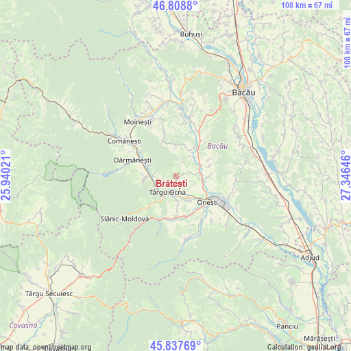
Brătești GPS coordinates[2]
46° 19' 31.44" North, 26° 38' 35.988" East
| Map corner | latitude | longitude |
|---|---|---|
| Upper-left | 46.8088°, | 25.94021° |
| Center: | 46.3254°, | 26.64333° |
| Lower-right: | 45.83769°, | 27.34646° |
| Map W x H: | 108×108 km | = 67.1×67.1mi |
| max Lat: | 48.23793° ⇑37.2% North |
| Brătești: | 46.3254° |
| min Lat: | ⇓62.8% South 43.65638° |
| min Long | Brătești | max Long |
| 20.31667° | 26.64333° | 29.65403° |
| W 75.4%⇐ | ⇒24.6% E |
Elevation
Elevation of Brătești is 445 m = 1460 ft, and this is 190.1 m = 624 ft above average elevation for this country.
| Max E: |
1278 m = 4193 ft | 15.1% |
| Brătești | 445 m 1460 ft | |
| Avg. | 254.9 m = 836 ft | |
Min E: |
-2 m = -7 ft | 84.9% |
See also: Romania elevation on elevation.city.
Geographical zone
Brătești is located in North temperate zone (between Tropic of Cancer and the Arctic Circle). Distance of this North polar circle is 2250.3 km =1398.3 mi to North.| Distance of | km | miles | from Brătești |
|---|---|---|---|
| North Pole | 4856.2 | 3017.5 | to North |
| Arctic Circle | 2250.3 | 1398.3 | to North |
| Tropic Cancer | 2545 | 1581.4 | to South |
| Equator | 5150.9 | 3200.6 | to South |


Nearby cities:
15 places around Brătești: (largest is in red/bold)
• Albele
5 km =3.1 mi,  27°
27°
• Berzunţi
8.3 km =5.2 mi,  354°
354°
• Bogata
7 km =4.3 mi,  246°
246°
• Bârsăneşti
4.4 km =2.7 mi,  78°
78°
• Caraclău
6 km =3.7 mi,  110°
110°
• Cucuieți
6.8 km =4.2 mi,  271°
271°
• Gura Văii
7 km =4.3 mi, 82°
• Poiana
8 km =5 mi,  41°
41°
• Poieni
7.5 km =4.7 mi,  231°
231°
• Pârgăreşti
8.4 km =5.2 mi,  176°
176°
• Tuta
8.5 km =5.3 mi,  154°
154°
• Târgu Ocna
5.7 km =3.5 mi,  204°
204°
• Târgu Trotuş
6.8 km =4.2 mi,  164°
164°
• Viișoara
4.9 km =3 mi, 163°
• Vâlcele
4.5 km =2.8 mi, 227°
Sources, notices
• [Note1] Compared only with cities in Romania existing in our database
• [Src1] Map data: © OpenStreetMap contributors (CC-BY-SA)
• [Src2] Other city data from geonames.org with taken over terms of usage.
• [Src3] Geographical zone / Annual Mean Temperature by Robert A. Rohde @ Wikipedia
