Viișoara geodata
Viișoara (Bistriţa-Năsăud) is a section of populated place; located in Romania in Europe/Bucharest (GMT+3) time zone. With population of 1,120 people, there are 3933 cities with bigger population in this country. Compared to other cities in Romania, 81.5% of cities are located further ↓South; 60.9% of cities are located further →East and 72.5% of cities have lower elevation than Viișoara. Note1


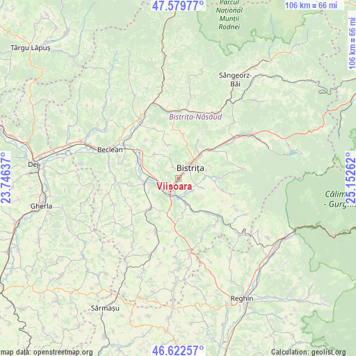
Viișoara GPS coordinates[2]
47° 6' 11.952" North, 24° 26' 58.164" East
| Map corner | latitude | longitude |
|---|---|---|
| Upper-left | 47.57977°, | 23.74637° |
| Center: | 47.10332°, | 24.44949° |
| Lower-right: | 46.62257°, | 25.15262° |
| Map W x H: | 106.4×106.4 km | = 66.1×66.1mi |
| max Lat: | 48.23793° ⇑18.5% North |
| Viișoara: | 47.10332° |
| min Lat: | ⇓81.5% South 43.65638° |
| min Long | Viișoara | max Long |
| 20.31667° | 24.44949° | 29.65403° |
| W 39.1%⇐ | ⇒60.9% E |
Elevation
Elevation of Viișoara is 337 m = 1106 ft, and this is 82.1 m = 269 ft above average elevation for this country.
| Max E: |
1278 m = 4193 ft | 27.5% |
| Viișoara | 337 m 1106 ft | |
| Avg. | 254.9 m = 836 ft | |
Min E: |
-2 m = -7 ft | 72.5% |
See also: Romania elevation on elevation.city.
Geographical zone
Viișoara is located in North temperate zone (between Tropic of Cancer and the Arctic Circle). Distance of this North polar circle is 2163.8 km =1344.5 mi to North.| Distance of | km | miles | from Viișoara |
|---|---|---|---|
| North Pole | 4769.7 | 2963.8 | to North |
| Arctic Circle | 2163.8 | 1344.5 | to North |
| Tropic Cancer | 2631.5 | 1635.1 | to South |
| Equator | 5237.4 | 3254.4 | to South |


Nearby cities:
15 places around Viișoara: (largest is in red/bold)
• Arcalia
6.8 km =4.2 mi,  248°
248°
• Bistriţa
5.1 km =3.2 mi,  49°
49°
• Budacu de Jos
5.5 km =3.4 mi,  113°
113°
• Buduș
7.1 km =4.4 mi, 110°
• Chintelnic
8.5 km =5.3 mi,  268°
268°
• Chiraleș
10.2 km =6.3 mi,  260°
260°
• Crainimăt
5.1 km =3.2 mi,  225°
225°
• Domnești
7.7 km =4.8 mi,  164°
164°
• Ghinda
10.1 km =6.3 mi,  68°
68°
• Jelna
8.1 km =5 mi,  85°
85°
• Sigmir
3.9 km =2.4 mi,  334°
334°
• Sărata
3.5 km =2.2 mi,  196°
196°
• Tărpiu
10.5 km =6.5 mi,  341°
341°
• Unirea
8.9 km =5.5 mi,  43°
43°
• Şieu-Măgheruş
5.5 km =3.4 mi, 246°
Sources, notices
• [Note1] Compared only with cities in Romania existing in our database
• [Src1] Map data: © OpenStreetMap contributors (CC-BY-SA)
• [Src2] Other city data from geonames.org with taken over terms of usage.
• [Src3] Geographical zone / Annual Mean Temperature by Robert A. Rohde @ Wikipedia
