Veleni geodata
Veleni (Dolj) is a populated place; located in Romania in Europe/Bucharest (GMT+3) time zone. With population of 721 people, there are 5456 cities with bigger population in this country. Compared to other cities in Romania, 88.8% of cities are located further ↑North; 79.9% of cities are located further →East and 53.1% of cities have higher elevation than Veleni. Note1


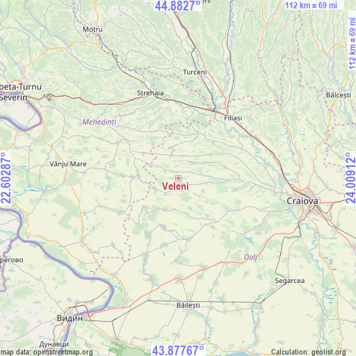
Veleni GPS coordinates[2]
44° 22' 56.424" North, 23° 18' 21.564" East
| Map corner | latitude | longitude |
|---|---|---|
| Upper-left | 44.8827°, | 22.60287° |
| Center: | 44.38234°, | 23.30599° |
| Lower-right: | 43.87767°, | 24.00912° |
| Map W x H: | 111.7×111.7 km | = 69.4×69.4mi |
| max Lat: | 48.23793° ⇑88.8% North |
| Veleni: | 44.38234° |
| min Lat: | ⇓11.2% South 43.65638° |
| min Long | Veleni | max Long |
| 20.31667° | 23.30599° | 29.65403° |
| W 20.1%⇐ | ⇒79.9% E |
Elevation
Elevation of Veleni is 196 m = 643 ft, and this is 58.9 m = 193 ft below average elevation for this country.
| Max E: |
1278 m = 4193 ft | 53.1% |
| Avg. | 254.9 m = 836 ft | |
| Veleni | 196 m = 643 ft | |
Min E: |
-2 m = -7 ft | 46.9% |
See also: Romania elevation on elevation.city.
Geographical zone
Veleni is located in North temperate zone (between Tropic of Cancer and the Arctic Circle). Distance of this Northern Tropic circle is 2328.9 km =1447.1 mi to South.| Distance of | km | miles | from Veleni |
|---|---|---|---|
| North Pole | 5072.2 | 3151.7 | to North |
| Arctic Circle | 2466.3 | 1532.5 | to North |
| Tropic Cancer | 2328.9 | 1447.1 | to South |
| Equator | 4934.9 | 3066.4 | to South |


Nearby cities:
15 places around Veleni: (largest is in red/bold)
• Botoşeşti-Paia
3.7 km =2.3 mi,  302°
302°
• Brabova
10.3 km =6.4 mi,  99°
99°
• Bucovicior
10 km =6.2 mi,  157°
157°
• Busu
9.9 km =6.2 mi,  320°
320°
• Bărboi
7.2 km =4.5 mi,  10°
10°
• Carpen
7 km =4.3 mi,  219°
219°
• Cleanov
8.3 km =5.2 mi,  246°
246°
• Călugărei
10.6 km =6.6 mi,  202°
202°
• Gogoşu
6.1 km =3.8 mi,  51°
51°
• Greceşti
7.7 km =4.8 mi,  346°
346°
• Răchita de Jos
8.8 km =5.5 mi,  117°
117°
• Seaca de Pădure
1.8 km =1.1 mi,  180°
180°
• Secu
9.4 km =5.8 mi,  357°
357°
• Urdinița
9.6 km =6 mi,  85°
85°
• Țiu
9.3 km =5.8 mi,  40°
40°
Sources, notices
• [Note1] Compared only with cities in Romania existing in our database
• [Src1] Map data: © OpenStreetMap contributors (CC-BY-SA)
• [Src2] Other city data from geonames.org with taken over terms of usage.
• [Src3] Geographical zone / Annual Mean Temperature by Robert A. Rohde @ Wikipedia
