Bucovicior geodata
Bucovicior (Dolj) is a populated place; located in Romania in Europe/Bucharest (GMT+3) time zone. With population of 577 people, there are 6377 cities with bigger population in this country. Compared to other cities in Romania, 90.8% of cities are located further ↑North; 79.1% of cities are located further →East and 51.7% of cities have lower elevation than Bucovicior. Note1


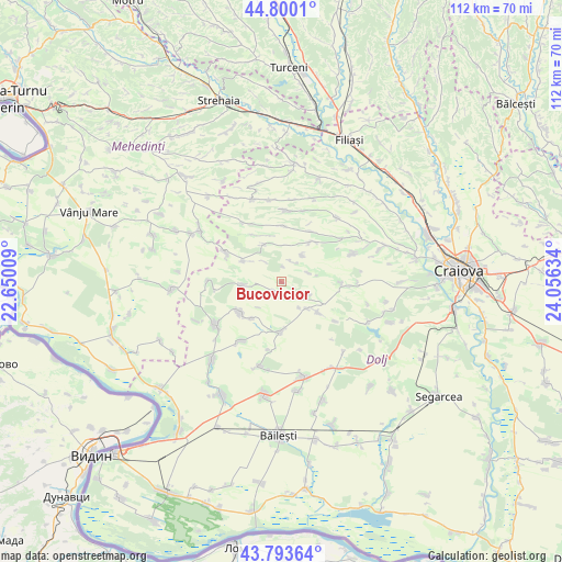
Bucovicior GPS coordinates[2]
44° 17' 56.508" North, 23° 21' 11.556" East
| Map corner | latitude | longitude |
|---|---|---|
| Upper-left | 44.8001°, | 22.65009° |
| Center: | 44.29903°, | 23.35321° |
| Lower-right: | 43.79364°, | 24.05634° |
| Map W x H: | 111.9×111.9 km | = 69.5×69.5mi |
| max Lat: | 48.23793° ⇑90.8% North |
| Bucovicior: | 44.29903° |
| min Lat: | ⇓9.2% South 43.65638° |
| min Long | Bucovicior | max Long |
| 20.31667° | 23.35321° | 29.65403° |
| W 20.9%⇐ | ⇒79.1% E |
Elevation
Elevation of Bucovicior is 220 m = 722 ft, and this is 34.9 m = 115 ft below average elevation for this country.
| Max E: |
1278 m = 4193 ft | 48.3% |
| Avg. | 254.9 m = 836 ft | |
| Bucovicior | 220 m = 722 ft | |
Min E: |
-2 m = -7 ft | 51.7% |
See also: Romania elevation on elevation.city.
Geographical zone
Bucovicior is located in North temperate zone (between Tropic of Cancer and the Arctic Circle). Distance of this Northern Tropic circle is 2319.7 km =1441.4 mi to South.| Distance of | km | miles | from Bucovicior |
|---|---|---|---|
| North Pole | 5081.5 | 3157.5 | to North |
| Arctic Circle | 2475.6 | 1538.3 | to North |
| Tropic Cancer | 2319.7 | 1441.4 | to South |
| Equator | 4925.6 | 3060.6 | to South |


Nearby cities:
15 places around Bucovicior: (largest is in red/bold)
• Brabova
9.9 km =6.2 mi,  40°
40°
• Carpen
9.1 km =5.7 mi,  294°
294°
• Cornu
9.5 km =5.9 mi,  220°
220°
• Căciulatu
5.7 km =3.5 mi,  72°
72°
• Călugărei
7.8 km =4.8 mi,  266°
266°
• Gubaucea
2.2 km =1.4 mi,  200°
200°
• Orodel
12 km =7.5 mi,  232°
232°
• Plopșor
7.3 km =4.5 mi,  138°
138°
• Răchita de Jos
6.6 km =4.1 mi, 38°
• Seaca de Pădure
8.4 km =5.2 mi,  333°
333°
• Sălcuţa
8.4 km =5.2 mi,  130°
130°
• Urdinița
11.6 km =7.2 mi,  30°
30°
• Vela
5.3 km =3.3 mi,  109°
109°
• Veleni
10 km =6.2 mi,  337°
337°
• Vârtop
10.3 km =6.4 mi,  182°
182°
Sources, notices
• [Note1] Compared only with cities in Romania existing in our database
• [Src1] Map data: © OpenStreetMap contributors (CC-BY-SA)
• [Src2] Other city data from geonames.org with taken over terms of usage.
• [Src3] Geographical zone / Annual Mean Temperature by Robert A. Rohde @ Wikipedia
