Valea geodata
Valea (Dâmboviţa) is a populated place; located in Romania in Europe/Bucharest (GMT+3) time zone. With population of 781 people, there are 5142 cities with bigger population in this country. Compared to other cities in Romania, 65.1% of cities are located further ↑North; 50.7% of cities are located further ←West and 84.7% of cities have lower elevation than Valea. Note1


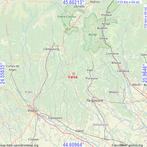
Valea GPS coordinates[2]
45° 6' 28.944" North, 25° 15' 41.292" East
| Map corner | latitude | longitude |
|---|---|---|
| Upper-left | 45.60213°, | 24.55835° |
| Center: | 45.10804°, | 25.26147° |
| Lower-right: | 44.60964°, | 25.9646° |
| Map W x H: | 110.4×110.4 km | = 68.6×68.6mi |
| max Lat: | 48.23793° ⇑65.1% North |
| Valea: | 45.10804° |
| min Lat: | ⇓34.9% South 43.65638° |
| min Long | Valea | max Long |
| 20.31667° | 25.26147° | 29.65403° |
| W 50.7%⇐ | ⇒49.3% E |
Elevation
Elevation of Valea is 443 m = 1453 ft, and this is 188.1 m = 617 ft above average elevation for this country.
| Max E: |
1278 m = 4193 ft | 15.3% |
| Valea | 443 m 1453 ft | |
| Avg. | 254.9 m = 836 ft | |
Min E: |
-2 m = -7 ft | 84.7% |
See also: Romania elevation on elevation.city.
Geographical zone
Valea is located in North temperate zone (between Tropic of Cancer and the Arctic Circle). Distance of this North polar circle is 2385.6 km =1482.3 mi to North.| Distance of | km | miles | from Valea |
|---|---|---|---|
| North Pole | 4991.5 | 3101.6 | to North |
| Arctic Circle | 2385.6 | 1482.3 | to North |
| Tropic Cancer | 2409.6 | 1497.3 | to South |
| Equator | 5015.5 | 3116.5 | to South |


Nearby cities:
15 places around Valea: (largest is in red/bold)
• Bărbuleţu
4.1 km =2.5 mi,  47°
47°
• Cetățuia
6.5 km =4 mi,  25°
25°
• Cândeşti Vale
4.5 km =2.8 mi,  231°
231°
• Dragodănești
6.2 km =3.9 mi,  198°
198°
• Gemenea Brătulești
2.3 km =1.4 mi,  270°
270°
• Gura Bărbulețului
3.4 km =2.1 mi,  64°
64°
• Malu cu Flori
6.7 km =4.2 mi,  314°
314°
• Manga
4.4 km =2.7 mi,  164°
164°
• Oncești
3.7 km =2.3 mi, 271°
• Pietrari
2.9 km =1.8 mi,  122°
122°
• Râu Alb de Jos
7.5 km =4.7 mi, 64°
• Râu Alb de Sus
7.8 km =4.8 mi,  41°
41°
• Suduleni
6.6 km =4.1 mi,  165°
165°
• Voineşti
4.7 km =2.9 mi,  191°
191°
• Vulcana de Sus
7.6 km =4.7 mi,  95°
95°
Sources, notices
• [Note1] Compared only with cities in Romania existing in our database
• [Src1] Map data: © OpenStreetMap contributors (CC-BY-SA)
• [Src2] Other city data from geonames.org with taken over terms of usage.
• [Src3] Geographical zone / Annual Mean Temperature by Robert A. Rohde @ Wikipedia
