Urechești geodata
Urechești (Gorj) is a populated place; located in Romania in Europe/Bucharest (GMT+3) time zone. With population of 913 people, there are 4565 cities with bigger population in this country. Compared to other cities in Romania, 71.1% of cities are located further ↑North; 80.5% of cities are located further →East and 51.8% of cities have lower elevation than Urechești. Note1


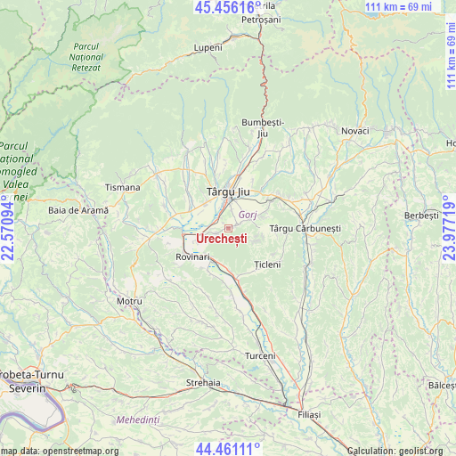
Urechești GPS coordinates[2]
44° 57' 38.844" North, 23° 16' 26.616" East
| Map corner | latitude | longitude |
|---|---|---|
| Upper-left | 45.45616°, | 22.57094° |
| Center: | 44.96079°, | 23.27406° |
| Lower-right: | 44.46111°, | 23.97719° |
| Map W x H: | 110.6×110.6 km | = 68.7×68.7mi |
| max Lat: | 48.23793° ⇑71.1% North |
| Urechești: | 44.96079° |
| min Lat: | ⇓28.9% South 43.65638° |
| min Long | Urechești | max Long |
| 20.31667° | 23.27406° | 29.65403° |
| W 19.5%⇐ | ⇒80.5% E |
Elevation
Elevation of Urechești is 221 m = 725 ft, and this is 33.9 m = 111 ft below average elevation for this country.
| Max E: |
1278 m = 4193 ft | 48.2% |
| Avg. | 254.9 m = 836 ft | |
| Urechești | 221 m = 725 ft | |
Min E: |
-2 m = -7 ft | 51.8% |
See also: Romania elevation on elevation.city.
Geographical zone
Urechești is located in North temperate zone (between Tropic of Cancer and the Arctic Circle). Distance of this Northern Tropic circle is 2393.3 km =1487.1 mi to South.| Distance of | km | miles | from Urechești |
|---|---|---|---|
| North Pole | 5007.9 | 3111.8 | to North |
| Arctic Circle | 2402 | 1492.5 | to North |
| Tropic Cancer | 2393.3 | 1487.1 | to South |
| Equator | 4999.2 | 3106.4 | to South |


Nearby cities:
15 places around Urechești: (largest is in red/bold)
• Bâlteni
10.2 km =6.3 mi,  180°
180°
• Băleşti
7.7 km =4.8 mi,  324°
324°
• Ceauru
8 km =5 mi, 315°
• Drăgoieni
10.3 km =6.4 mi,  28°
28°
• Drăguţeşti
3.3 km =2.1 mi,  281°
281°
• Dăneşti
4.7 km =2.9 mi,  82°
82°
• Iași-Gorj
4.2 km =2.6 mi,  330°
330°
• Moi
8.4 km =5.2 mi,  217°
217°
• Romanești
5.7 km =3.5 mi,  352°
352°
• Rovinari
8.7 km =5.4 mi,  235°
235°
• Slobozia
8.3 km =5.2 mi,  336°
336°
• Târgu Jiu
9.9 km =6.2 mi,  4°
4°
• Tămășești
7.8 km =4.8 mi,  299°
299°
• Vlăduleni
8.5 km =5.3 mi,  199°
199°
• Văcarea
2.2 km =1.4 mi,  72°
72°
Sources, notices
• [Note1] Compared only with cities in Romania existing in our database
• [Src1] Map data: © OpenStreetMap contributors (CC-BY-SA)
• [Src2] Other city data from geonames.org with taken over terms of usage.
• [Src3] Geographical zone / Annual Mean Temperature by Robert A. Rohde @ Wikipedia
