Ceauru geodata
Ceauru (Gorj) is a populated place; located in Romania in Europe/Bucharest (GMT+3) time zone. With population of 2,295 people, there are 2330 cities with bigger population in this country. Compared to other cities in Romania, 69.5% of cities are located further ↑North; 81.4% of cities are located further →East and 56.6% of cities have higher elevation than Ceauru. Note1


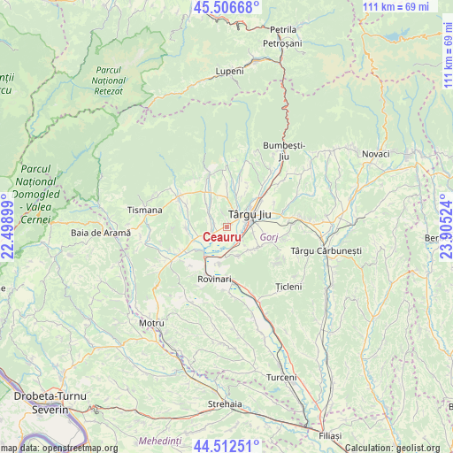
Ceauru GPS coordinates[2]
45° 0' 42.3" North, 23° 12' 7.596" East
| Map corner | latitude | longitude |
|---|---|---|
| Upper-left | 45.50668°, | 22.49899° |
| Center: | 45.01175°, | 23.20211° |
| Lower-right: | 44.51251°, | 23.90524° |
| Map W x H: | 110.5×110.5 km | = 68.7×68.7mi |
| max Lat: | 48.23793° ⇑69.5% North |
| Ceauru: | 45.01175° |
| min Lat: | ⇓30.5% South 43.65638° |
| min Long | Ceauru | max Long |
| 20.31667° | 23.20211° | 29.65403° |
| W 18.6%⇐ | ⇒81.4% E |
Elevation
Elevation of Ceauru is 180 m = 591 ft, and this is 74.9 m = 246 ft below average elevation for this country.
| Max E: |
1278 m = 4193 ft | 56.6% |
| Avg. | 254.9 m = 836 ft | |
| Ceauru | 180 m = 591 ft | |
Min E: |
-2 m = -7 ft | 43.4% |
See also: Romania elevation on elevation.city.
Geographical zone
Ceauru is located in North temperate zone (between Tropic of Cancer and the Arctic Circle). Distance of this North polar circle is 2396.3 km =1489 mi to North.| Distance of | km | miles | from Ceauru |
|---|---|---|---|
| North Pole | 5002.2 | 3108.2 | to North |
| Arctic Circle | 2396.3 | 1489 | to North |
| Tropic Cancer | 2398.9 | 1490.6 | to South |
| Equator | 5004.8 | 3109.8 | to South |


Nearby cities:
15 places around Ceauru: (largest is in red/bold)
• Buduhala
6.5 km =4 mi,  242°
242°
• Bârsești
4.9 km =3 mi,  29°
29°
• Băleşti
1.3 km =0.8 mi,  64°
64°
• Drăguţeşti
5.6 km =3.5 mi,  153°
153°
• Iași-Gorj
4.2 km =2.6 mi,  119°
119°
• Rasova
4.2 km =2.6 mi,  339°
339°
• Romanești
4.9 km =3 mi,  90°
90°
• Slobozia
3 km =1.9 mi,  49°
49°
• Târgu Jiu
7.7 km =4.8 mi, 56°
• Tălpășești
3.6 km =2.2 mi,  294°
294°
• Tămășești
2.2 km =1.4 mi,  211°
211°
• Urechești
8 km =5 mi,  135°
135°
• Vârț
8.7 km =5.4 mi,  218°
218°
• Văcarea
9.2 km =5.7 mi, 122°
• Șomănești
8.9 km =5.5 mi,  230°
230°
Sources, notices
• [Note1] Compared only with cities in Romania existing in our database
• [Src1] Map data: © OpenStreetMap contributors (CC-BY-SA)
• [Src2] Other city data from geonames.org with taken over terms of usage.
• [Src3] Geographical zone / Annual Mean Temperature by Robert A. Rohde @ Wikipedia
