Slobozia geodata
Slobozia (Gorj) is a populated place; located in Romania in Europe/Bucharest (GMT+3) time zone. With population of 756 people, there are 5257 cities with bigger population in this country. Compared to other cities in Romania, 68.7% of cities are located further ↑North; 81.1% of cities are located further →East and 53.7% of cities have higher elevation than Slobozia. Note1


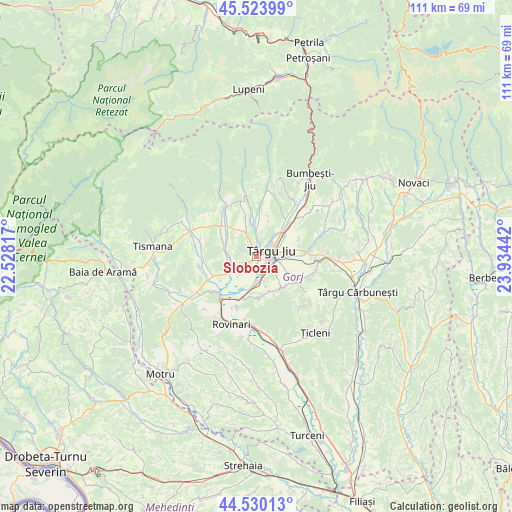
Slobozia GPS coordinates[2]
45° 1' 45.192" North, 23° 13' 52.644" East
| Map corner | latitude | longitude |
|---|---|---|
| Upper-left | 45.52399°, | 22.52817° |
| Center: | 45.02922°, | 23.23129° |
| Lower-right: | 44.53013°, | 23.93442° |
| Map W x H: | 110.5×110.5 km | = 68.7×68.7mi |
| max Lat: | 48.23793° ⇑68.7% North |
| Slobozia: | 45.02922° |
| min Lat: | ⇓31.3% South 43.65638° |
| min Long | Slobozia | max Long |
| 20.31667° | 23.23129° | 29.65403° |
| W 18.9%⇐ | ⇒81.1% E |
Elevation
Elevation of Slobozia is 193 m = 633 ft, and this is 61.9 m = 203 ft below average elevation for this country.
| Max E: |
1278 m = 4193 ft | 53.7% |
| Avg. | 254.9 m = 836 ft | |
| Slobozia | 193 m = 633 ft | |
Min E: |
-2 m = -7 ft | 46.3% |
See also: Romania elevation on elevation.city.
Geographical zone
Slobozia is located in North temperate zone (between Tropic of Cancer and the Arctic Circle). Distance of this North polar circle is 2394.4 km =1487.8 mi to North.| Distance of | km | miles | from Slobozia |
|---|---|---|---|
| North Pole | 5000.3 | 3107 | to North |
| Arctic Circle | 2394.4 | 1487.8 | to North |
| Tropic Cancer | 2400.9 | 1491.8 | to South |
| Equator | 5006.8 | 3111.1 | to South |


Nearby cities:
15 places around Slobozia: (largest is in red/bold)
• Buduhala
9.5 km =5.9 mi,  238°
238°
• Bârsești
2.3 km =1.4 mi,  3°
3°
• Băleşti
1.8 km =1.1 mi,  219°
219°
• Ceauru
3 km =1.9 mi,  229°
229°
• Drăgoieni
8.4 km =5.2 mi,  80°
80°
• Drăguţeşti
7 km =4.3 mi,  178°
178°
• Iași-Gorj
4.2 km =2.6 mi,  161°
161°
• Leleşti
8.2 km =5.1 mi,  342°
342°
• Rasova
4.3 km =2.7 mi,  298°
298°
• Romanești
3.3 km =2.1 mi,  126°
126°
• Târgu Jiu
4.7 km =2.9 mi,  60°
60°
• Tălpășești
5.5 km =3.4 mi,  265°
265°
• Tămășești
5.1 km =3.2 mi, 222°
• Urechești
8.3 km =5.2 mi, 156°
• Văcarea
8.8 km =5.5 mi,  141°
141°
Sources, notices
• [Note1] Compared only with cities in Romania existing in our database
• [Src1] Map data: © OpenStreetMap contributors (CC-BY-SA)
• [Src2] Other city data from geonames.org with taken over terms of usage.
• [Src3] Geographical zone / Annual Mean Temperature by Robert A. Rohde @ Wikipedia
