Ungureni geodata
Ungureni (Bacău) is a section of populated place; located in Romania in Europe/Bucharest (GMT+3) time zone. With population of 3,728 people, there are 1304 cities with bigger population in this country. Compared to other cities in Romania, 67.4% of cities are located further ↓South; 82.1% of cities are located further ←West and 66.5% of cities have higher elevation than Ungureni. Note1


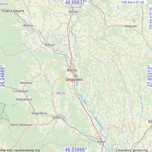
Ungureni GPS coordinates[2]
46° 31' 0.012" North, 26° 57' 0" East
| Map corner | latitude | longitude |
|---|---|---|
| Upper-left | 46.99837°, | 26.24688° |
| Center: | 46.51667°, | 26.95° |
| Lower-right: | 46.03066°, | 27.65313° |
| Map W x H: | 107.6×107.6 km | = 66.9×66.9mi |
| max Lat: | 48.23793° ⇑32.6% North |
| Ungureni: | 46.51667° |
| min Lat: | ⇓67.4% South 43.65638° |
| min Long | Ungureni | max Long |
| 20.31667° | 26.95° | 29.65403° |
| W 82.1%⇐ | ⇒17.9% E |
Elevation
Elevation of Ungureni is 141 m = 463 ft, and this is 113.9 m = 374 ft below average elevation for this country.
| Max E: |
1278 m = 4193 ft | 66.5% |
| Avg. | 254.9 m = 836 ft | |
| Ungureni | 141 m = 463 ft | |
Min E: |
-2 m = -7 ft | 33.5% |
See also: Romania elevation on elevation.city.
Geographical zone
Ungureni is located in North temperate zone (between Tropic of Cancer and the Arctic Circle). Distance of this North polar circle is 2229 km =1385 mi to North.| Distance of | km | miles | from Ungureni |
|---|---|---|---|
| North Pole | 4834.9 | 3004.3 | to North |
| Arctic Circle | 2229 | 1385 | to North |
| Tropic Cancer | 2566.2 | 1594.6 | to South |
| Equator | 5172.2 | 3213.9 | to South |


Nearby cities:
15 places around Ungureni: (largest is in red/bold)
• Bacău
6.3 km =3.9 mi,  333°
333°
• Barați
8.9 km =5.5 mi,  317°
317°
• Buchila
8.7 km =5.4 mi,  218°
218°
• Buhoci
7.5 km =4.7 mi,  42°
42°
• Chetriș
6.5 km =4 mi,  150°
150°
• Dămoc
8.5 km =5.3 mi,  228°
228°
• Furnicari
3.8 km =2.4 mi,  104°
104°
• Galbeni
6.7 km =4.2 mi,  182°
182°
• Holt
7.1 km =4.4 mi,  15°
15°
• Letea Veche
3.7 km =2.3 mi,  0°
0°
• Nicolae Bălcescu
6.1 km =3.8 mi,  204°
204°
• Osebiți
8.8 km =5.5 mi,  285°
285°
• Sărata
6.4 km =4 mi,  255°
255°
• Tamaşi
4.5 km =2.8 mi, 145°
• Valea Seacă
7.8 km =4.8 mi, 222°
Sources, notices
• [Note1] Compared only with cities in Romania existing in our database
• [Src1] Map data: © OpenStreetMap contributors (CC-BY-SA)
• [Src2] Other city data from geonames.org with taken over terms of usage.
• [Src3] Geographical zone / Annual Mean Temperature by Robert A. Rohde @ Wikipedia
