Bacău geodata
Bacău is a seat of a first-order administrative division; located in Romania in Europe/Bucharest (GMT+3) time zone. With population of 171,396 people, there are 17 cities with bigger population in this country. Compared to other cities in Romania, 68.7% of cities are located further ↓South; 81.3% of cities are located further ←West and 60.2% of cities have higher elevation than Bacău. Note1


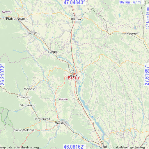
Bacău GPS coordinates[2]
46° 34' 1.848" North, 26° 54' 49.824" East
| Map corner | latitude | longitude |
|---|---|---|
| Upper-left | 47.04843°, | 26.21072° |
| Center: | 46.56718°, | 26.91384° |
| Lower-right: | 46.08162°, | 27.61697° |
| Map W x H: | 107.5×107.5 km | = 66.8×66.8mi |
| max Lat: | 48.23793° ⇑31.3% North |
| Bacău: | 46.56718° |
| min Lat: | ⇓68.7% South 43.65638° |
| min Long | Bacău | max Long |
| 20.31667° | 26.91384° | 29.65403° |
| W 81.3%⇐ | ⇒18.7% E |
Elevation
Elevation of Bacău is 165 m = 541 ft, and this is 89.9 m = 295 ft below average elevation for this country.
| Max E: |
1278 m = 4193 ft | 60.2% |
| Avg. | 254.9 m = 836 ft | |
| Bacău | 165 m = 541 ft | |
Min E: |
-2 m = -7 ft | 39.8% |
See also: Bacău elevation on elevation.city.
Geographical zone
Bacău is located in North temperate zone (between Tropic of Cancer and the Arctic Circle). Distance of this North polar circle is 2223.4 km =1381.6 mi to North.| Distance of | km | miles | from Bacău |
|---|---|---|---|
| North Pole | 4829.3 | 3000.8 | to North |
| Arctic Circle | 2223.4 | 1381.6 | to North |
| Tropic Cancer | 2571.9 | 1598.1 | to South |
| Equator | 5177.8 | 3217.3 | to South |


Nearby cities:
15 places around Bacău: (largest is in red/bold)
• Barați
3.4 km =2.1 mi,  286°
286°
• Buhoci
7.9 km =4.9 mi,  90°
90°
• Hemeiuș
8 km =5 mi,  325°
325°
• Holt
4.8 km =3 mi,  74°
74°
• Letea Veche
3.4 km =2.1 mi,  124°
124°
• Lilieci
7.5 km =4.7 mi, 334°
• Luizi-Călugăra
7.2 km =4.5 mi,  238°
238°
• Măgura
4.9 km =3 mi,  269°
269°
• Mărgineni
5.3 km =3.3 mi,  295°
295°
• Mărgineni-Munteni
3.8 km =2.4 mi,  343°
343°
• Osebiți
6.5 km =4 mi, 240°
• Schineni
8.7 km =5.4 mi,  17°
17°
• Sărata
8 km =5 mi,  205°
205°
• Săucești
6.1 km =3.8 mi, 20°
• Ungureni
6.3 km =3.9 mi,  153°
153°
Sources, notices
• [Note1] Compared only with cities in Romania existing in our database
• [Src1] Map data: © OpenStreetMap contributors (CC-BY-SA)
• [Src2] Other city data from geonames.org with taken over terms of usage.
• [Src3] Geographical zone / Annual Mean Temperature by Robert A. Rohde @ Wikipedia
