Tamaşi geodata
Tamaşi (Bacău) is a seat of a second-order administrative division; located in Romania in Europe/Bucharest (GMT+3) time zone. With population of 6,330 people, there are 484 cities with bigger population in this country. Compared to other cities in Romania, 66.7% of cities are located further ↓South; 82.6% of cities are located further ←West and 66.5% of cities have higher elevation than Tamaşi. Note1


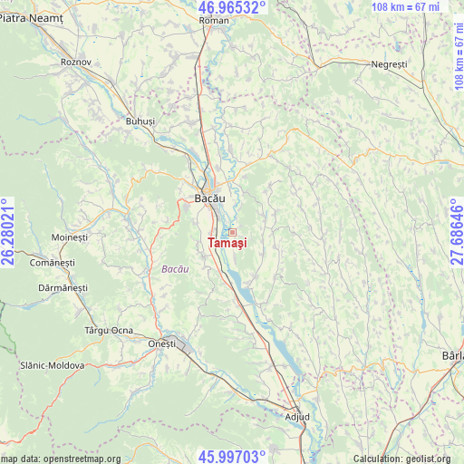
Tamaşi GPS coordinates[2]
46° 28' 59.988" North, 26° 58' 59.988" East
| Map corner | latitude | longitude |
|---|---|---|
| Upper-left | 46.96532°, | 26.28021° |
| Center: | 46.48333°, | 26.98333° |
| Lower-right: | 45.99703°, | 27.68646° |
| Map W x H: | 107.7×107.7 km | = 66.9×66.9mi |
| max Lat: | 48.23793° ⇑33.3% North |
| Tamaşi: | 46.48333° |
| min Lat: | ⇓66.7% South 43.65638° |
| min Long | Tamaşi | max Long |
| 20.31667° | 26.98333° | 29.65403° |
| W 82.6%⇐ | ⇒17.4% E |
Elevation
Elevation of Tamaşi is 141 m = 463 ft, and this is 113.9 m = 374 ft below average elevation for this country.
| Max E: |
1278 m = 4193 ft | 66.5% |
| Avg. | 254.9 m = 836 ft | |
| Tamaşi | 141 m = 463 ft | |
Min E: |
-2 m = -7 ft | 33.5% |
See also: Romania elevation on elevation.city.
Geographical zone
Tamaşi is located in North temperate zone (between Tropic of Cancer and the Arctic Circle). Distance of this North polar circle is 2232.7 km =1387.3 mi to North.| Distance of | km | miles | from Tamaşi |
|---|---|---|---|
| North Pole | 4838.6 | 3006.6 | to North |
| Arctic Circle | 2232.7 | 1387.3 | to North |
| Tropic Cancer | 2562.5 | 1592.3 | to South |
| Equator | 5168.5 | 3211.6 | to South |


Nearby cities:
15 places around Tamaşi: (largest is in red/bold)
• Bibirești
8.2 km =5.1 mi,  61°
61°
• Buchila
8.6 km =5.3 mi,  248°
248°
• Chetriș
2 km =1.2 mi,  161°
161°
• Faraoaní
8.5 km =5.3 mi,  228°
228°
• Furnicari
3 km =1.9 mi,  22°
22°
• Galbeni
4.1 km =2.5 mi,  223°
223°
• Gioseni
6.1 km =3.8 mi,  173°
173°
• Horgeşti
8.5 km =5.3 mi,  131°
131°
• Letea Veche
7.8 km =4.8 mi,  341°
341°
• Nicolae Bălcescu
5.4 km =3.4 mi, 250°
• Parincea
8.9 km =5.5 mi,  90°
90°
• Sărata
9 km =5.6 mi,  283°
283°
• Ungureni
4.5 km =2.8 mi,  325°
325°
• Valea Seacă
8.1 km =5 mi,  255°
255°
• Văleni
7.5 km =4.7 mi,  104°
104°
Sources, notices
• [Note1] Compared only with cities in Romania existing in our database
• [Src1] Map data: © OpenStreetMap contributors (CC-BY-SA)
• [Src2] Other city data from geonames.org with taken over terms of usage.
• [Src3] Geographical zone / Annual Mean Temperature by Robert A. Rohde @ Wikipedia
