Ungureni geodata
Ungureni (Dâmboviţa) is a populated place; located in Romania in Europe/Bucharest (GMT+3) time zone. With population of 1,994 people, there are 2604 cities with bigger population in this country. Compared to other cities in Romania, 83.4% of cities are located further ↑North; 54.6% of cities are located further ←West and 64.9% of cities have higher elevation than Ungureni. Note1


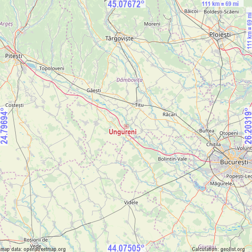
Ungureni GPS coordinates[2]
44° 34' 40.944" North, 25° 30' 0.216" East
| Map corner | latitude | longitude |
|---|---|---|
| Upper-left | 45.07672°, | 24.79694° |
| Center: | 44.57804°, | 25.50006° |
| Lower-right: | 44.07505°, | 26.20319° |
| Map W x H: | 111.4×111.4 km | = 69.2×69.2mi |
| max Lat: | 48.23793° ⇑83.4% North |
| Ungureni: | 44.57804° |
| min Lat: | ⇓16.6% South 43.65638° |
| min Long | Ungureni | max Long |
| 20.31667° | 25.50006° | 29.65403° |
| W 54.6%⇐ | ⇒45.4% E |
Elevation
Elevation of Ungureni is 147 m = 482 ft, and this is 107.9 m = 354 ft below average elevation for this country.
| Max E: |
1278 m = 4193 ft | 64.9% |
| Avg. | 254.9 m = 836 ft | |
| Ungureni | 147 m = 482 ft | |
Min E: |
-2 m = -7 ft | 35.1% |
See also: Romania elevation on elevation.city.
Geographical zone
Ungureni is located in North temperate zone (between Tropic of Cancer and the Arctic Circle). Distance of this Northern Tropic circle is 2350.7 km =1460.7 mi to South.| Distance of | km | miles | from Ungureni |
|---|---|---|---|
| North Pole | 5050.4 | 3138.2 | to North |
| Arctic Circle | 2444.6 | 1519 | to North |
| Tropic Cancer | 2350.7 | 1460.7 | to South |
| Equator | 4956.6 | 3079.9 | to South |


Nearby cities:
15 places around Ungureni: (largest is in red/bold)
• Brâncoveanu
4.5 km =2.8 mi,  42°
42°
• Corbii Mari
3.1 km =1.9 mi,  180°
180°
• Croitori
6.9 km =4.3 mi,  267°
267°
• Crovu
3.2 km =2 mi,  66°
66°
• Grozăvești
3.8 km =2.4 mi,  254°
254°
• Miulești
2.7 km =1.7 mi,  26°
26°
• Mărunțișu
5.5 km =3.4 mi,  5°
5°
• Odobeşti
6.8 km =4.2 mi,  50°
50°
• Petrești
4.7 km =2.9 mi,  241°
241°
• Pitaru
6.8 km =4.2 mi,  78°
78°
• Satu Nou
2.6 km =1.6 mi,  320°
320°
• Tomșani
7.1 km =4.4 mi,  1°
1°
• Ulieşti
6.6 km =4.1 mi,  275°
275°
• Vadu Stanchii
5.7 km =3.5 mi,  191°
191°
• Zidurile
4.3 km =2.7 mi, 84°
Sources, notices
• [Note1] Compared only with cities in Romania existing in our database
• [Src1] Map data: © OpenStreetMap contributors (CC-BY-SA)
• [Src2] Other city data from geonames.org with taken over terms of usage.
• [Src3] Geographical zone / Annual Mean Temperature by Robert A. Rohde @ Wikipedia
