Brâncoveanu geodata
Brâncoveanu (Dâmboviţa) is a populated place; located in Romania in Europe/Bucharest (GMT+3) time zone. With population of 800 people, there are 5046 cities with bigger population in this country. Compared to other cities in Romania, 82.6% of cities are located further ↑North; 55.1% of cities are located further ←West and 65.2% of cities have higher elevation than Brâncoveanu. Note1


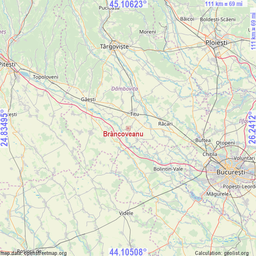
Brâncoveanu GPS coordinates[2]
44° 36' 28.116" North, 25° 32' 17.052" East
| Map corner | latitude | longitude |
|---|---|---|
| Upper-left | 45.10623°, | 24.83495° |
| Center: | 44.60781°, | 25.53807° |
| Lower-right: | 44.10508°, | 26.2412° |
| Map W x H: | 111.3×111.3 km | = 69.2×69.2mi |
| max Lat: | 48.23793° ⇑82.6% North |
| Brâncoveanu: | 44.60781° |
| min Lat: | ⇓17.4% South 43.65638° |
| min Long | Brâncoveanu | max Long |
| 20.31667° | 25.53807° | 29.65403° |
| W 55.1%⇐ | ⇒44.9% E |
Elevation
Elevation of Brâncoveanu is 146 m = 479 ft, and this is 108.9 m = 357 ft below average elevation for this country.
| Max E: |
1278 m = 4193 ft | 65.2% |
| Avg. | 254.9 m = 836 ft | |
| Brâncoveanu | 146 m = 479 ft | |
Min E: |
-2 m = -7 ft | 34.8% |
See also: Romania elevation on elevation.city.
Geographical zone
Brâncoveanu is located in North temperate zone (between Tropic of Cancer and the Arctic Circle). Distance of this Northern Tropic circle is 2354 km =1462.7 mi to South.| Distance of | km | miles | from Brâncoveanu |
|---|---|---|---|
| North Pole | 5047.1 | 3136.1 | to North |
| Arctic Circle | 2441.3 | 1517 | to North |
| Tropic Cancer | 2354 | 1462.7 | to South |
| Equator | 4959.9 | 3081.9 | to South |


Nearby cities:
15 places around Brâncoveanu: (largest is in red/bold)
• Costeştii din Vale
6.4 km =4 mi,  317°
317°
• Crovu
2 km =1.2 mi,  182°
182°
• Fusea
6 km =3.7 mi,  357°
357°
• Miulești
2 km =1.2 mi,  244°
244°
• Mărunțișu
3.3 km =2.1 mi,  311°
311°
• Odobeşti
2.5 km =1.6 mi,  66°
66°
• Pitaru
4.1 km =2.5 mi,  117°
117°
• Plopu
4.9 km =3 mi,  349°
349°
• Satu Nou
4.8 km =3 mi,  254°
254°
• Sălcuța
5.2 km =3.2 mi,  40°
40°
• Titu
4.7 km =2.9 mi, 355°
• Tomșani
4.7 km =2.9 mi, 323°
• Ungureni
4.5 km =2.8 mi,  222°
222°
• Vlăsceni
5.5 km =3.4 mi, 117°
• Zidurile
3.2 km =2 mi,  155°
155°
Sources, notices
• [Note1] Compared only with cities in Romania existing in our database
• [Src1] Map data: © OpenStreetMap contributors (CC-BY-SA)
• [Src2] Other city data from geonames.org with taken over terms of usage.
• [Src3] Geographical zone / Annual Mean Temperature by Robert A. Rohde @ Wikipedia
