Tureni geodata
Tureni (Cluj) is a seat of a second-order administrative division; located in Romania in Europe/Bucharest (GMT+3) time zone. With population of 2,545 people, there are 2119 cities with bigger population in this country. Compared to other cities in Romania, 70% of cities are located further ↓South; 74.2% of cities are located further →East and 90.5% of cities have lower elevation than Tureni. Note1


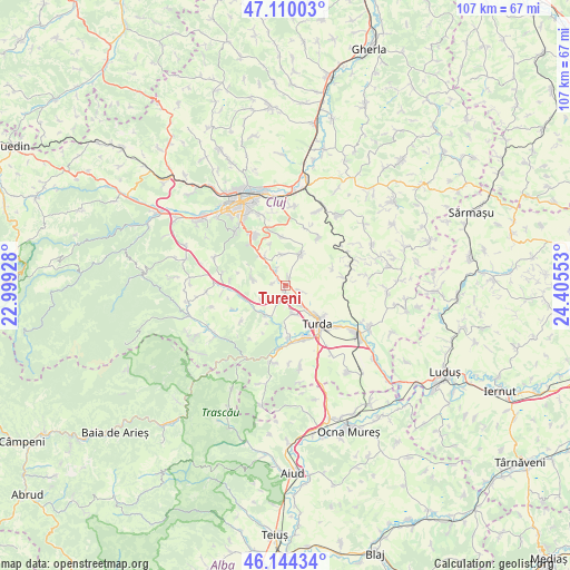
Tureni GPS coordinates[2]
46° 37' 45.624" North, 23° 42' 8.64" East
| Map corner | latitude | longitude |
|---|---|---|
| Upper-left | 47.11003°, | 22.99928° |
| Center: | 46.62934°, | 23.7024° |
| Lower-right: | 46.14434°, | 24.40553° |
| Map W x H: | 107.4×107.4 km | = 66.7×66.7mi |
| max Lat: | 48.23793° ⇑30% North |
| Tureni: | 46.62934° |
| min Lat: | ⇓70% South 43.65638° |
| min Long | Tureni | max Long |
| 20.31667° | 23.7024° | 29.65403° |
| W 25.8%⇐ | ⇒74.2% E |
Elevation
Elevation of Tureni is 521 m = 1709 ft, and this is 266.1 m = 873 ft above average elevation for this country.
| Max E: |
1278 m = 4193 ft | 9.5% |
| Tureni | 521 m 1709 ft | |
| Avg. | 254.9 m = 836 ft | |
Min E: |
-2 m = -7 ft | 90.5% |
See also: Romania elevation on elevation.city.
Geographical zone
Tureni is located in North temperate zone (between Tropic of Cancer and the Arctic Circle). Distance of this North polar circle is 2216.5 km =1377.3 mi to North.| Distance of | km | miles | from Tureni |
|---|---|---|---|
| North Pole | 4822.4 | 2996.5 | to North |
| Arctic Circle | 2216.5 | 1377.3 | to North |
| Tropic Cancer | 2578.8 | 1602.4 | to South |
| Equator | 5184.7 | 3221.6 | to South |


Nearby cities:
15 places around Tureni: (largest is in red/bold)
• Aiton
6.5 km =4 mi,  21°
21°
• Boju
10.8 km =6.7 mi,  33°
33°
• Ceanu Mic
1.6 km =1 mi, 24°
• Cheia
9.8 km =6.1 mi,  177°
177°
• Copăceni
4.6 km =2.9 mi,  142°
142°
• Gheorghieni
9.5 km =5.9 mi,  353°
353°
• Micești
6.6 km =4.1 mi,  282°
282°
• Mihai Viteazu
11.3 km =7 mi,  161°
161°
• Pata
11.4 km =7.1 mi, 17°
• Petreştii de Jos
6.5 km =4 mi,  218°
218°
• Ploscoș
11.1 km =6.9 mi,  82°
82°
• Rediu
5.9 km =3.7 mi, 352°
• Sănduleşti
5.2 km =3.2 mi,  167°
167°
• Turda
9.3 km =5.8 mi, 138°
• Vâlcele
7.4 km =4.6 mi,  329°
329°
Sources, notices
• [Note1] Compared only with cities in Romania existing in our database
• [Src1] Map data: © OpenStreetMap contributors (CC-BY-SA)
• [Src2] Other city data from geonames.org with taken over terms of usage.
• [Src3] Geographical zone / Annual Mean Temperature by Robert A. Rohde @ Wikipedia
