Cheia geodata
Cheia (Cluj) is a populated place; located in Romania in Europe/Bucharest (GMT+3) time zone. With population of 554 people, there are 6553 cities with bigger population in this country. Compared to other cities in Romania, 68% of cities are located further ↓South; 74.1% of cities are located further →East and 75.3% of cities have lower elevation than Cheia. Note1


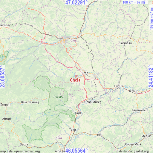
Cheia GPS coordinates[2]
46° 32' 29.148" North, 23° 42' 31.284" East
| Map corner | latitude | longitude |
|---|---|---|
| Upper-left | 47.02291°, | 23.00557° |
| Center: | 46.54143°, | 23.70869° |
| Lower-right: | 46.05564°, | 24.41182° |
| Map W x H: | 107.6×107.5 km | = 66.9×66.8mi |
| max Lat: | 48.23793° ⇑32% North |
| Cheia: | 46.54143° |
| min Lat: | ⇓68% South 43.65638° |
| min Long | Cheia | max Long |
| 20.31667° | 23.70869° | 29.65403° |
| W 25.9%⇐ | ⇒74.1% E |
Elevation
Elevation of Cheia is 355 m = 1165 ft, and this is 100.1 m = 328 ft above average elevation for this country.
| Max E: |
1278 m = 4193 ft | 24.7% |
| Cheia | 355 m 1165 ft | |
| Avg. | 254.9 m = 836 ft | |
Min E: |
-2 m = -7 ft | 75.3% |
See also: Romania elevation on elevation.city.
Geographical zone
Cheia is located in North temperate zone (between Tropic of Cancer and the Arctic Circle). Distance of this North polar circle is 2226.3 km =1383.4 mi to North.| Distance of | km | miles | from Cheia |
|---|---|---|---|
| North Pole | 4832.1 | 3002.5 | to North |
| Arctic Circle | 2226.3 | 1383.4 | to North |
| Tropic Cancer | 2569 | 1596.3 | to South |
| Equator | 5174.9 | 3215.5 | to South |


Nearby cities:
15 places around Cheia: (largest is in red/bold)
• Bogata
8.5 km =5.3 mi,  110°
110°
• Bădeni
6.2 km =3.9 mi,  160°
160°
• Ceanu Mic
11.3 km =7 mi,  0°
0°
• Copăceni
6.6 km =4.1 mi,  20°
20°
• Cornești
2.5 km =1.6 mi,  213°
213°
• Câmpia Turzii
13.4 km =8.3 mi,  85°
85°
• Călăraşi
13.7 km =8.5 mi,  118°
118°
• Micești
13.2 km =8.2 mi,  328°
328°
• Mihai Viteazu
3.3 km =2.1 mi, 105°
• Moldoveneşti
6.4 km =4 mi,  224°
224°
• Petreştii de Jos
6.5 km =4 mi,  316°
316°
• Plăiești
4.9 km =3 mi,  176°
176°
• Sănduleşti
4.7 km =2.9 mi,  7°
7°
• Turda
6.4 km =4 mi,  63°
63°
• Tureni
9.8 km =6.1 mi,  357°
357°
Sources, notices
• [Note1] Compared only with cities in Romania existing in our database
• [Src1] Map data: © OpenStreetMap contributors (CC-BY-SA)
• [Src2] Other city data from geonames.org with taken over terms of usage.
• [Src3] Geographical zone / Annual Mean Temperature by Robert A. Rohde @ Wikipedia
