Gheorghieni geodata
Gheorghieni (Cluj) is a populated place; located in Romania in Europe/Bucharest (GMT+3) time zone. With population of 1,226 people, there are 3688 cities with bigger population in this country. Compared to other cities in Romania, 72% of cities are located further ↓South; 74.3% of cities are located further →East and 92.3% of cities have lower elevation than Gheorghieni. Note1


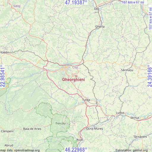
Gheorghieni GPS coordinates[2]
46° 42' 50.148" North, 23° 41' 18.708" East
| Map corner | latitude | longitude |
|---|---|---|
| Upper-left | 47.19387°, | 22.98541° |
| Center: | 46.71393°, | 23.68853° |
| Lower-right: | 46.22968°, | 24.39166° |
| Map W x H: | 107.2×107.2 km | = 66.6×66.6mi |
| max Lat: | 48.23793° ⇑28% North |
| Gheorghieni: | 46.71393° |
| min Lat: | ⇓72% South 43.65638° |
| min Long | Gheorghieni | max Long |
| 20.31667° | 23.68853° | 29.65403° |
| W 25.7%⇐ | ⇒74.3% E |
Elevation
Elevation of Gheorghieni is 556 m = 1824 ft, and this is 301.1 m = 988 ft above average elevation for this country.
| Max E: |
1278 m = 4193 ft | 7.7% |
| Gheorghieni | 556 m 1824 ft | |
| Avg. | 254.9 m = 836 ft | |
Min E: |
-2 m = -7 ft | 92.3% |
See also: Romania elevation on elevation.city.
Geographical zone
Gheorghieni is located in North temperate zone (between Tropic of Cancer and the Arctic Circle). Distance of this North polar circle is 2207.1 km =1371.4 mi to North.| Distance of | km | miles | from Gheorghieni |
|---|---|---|---|
| North Pole | 4813 | 2990.7 | to North |
| Arctic Circle | 2207.1 | 1371.4 | to North |
| Tropic Cancer | 2588.2 | 1608.2 | to South |
| Equator | 5194.1 | 3227.5 | to South |


Nearby cities:
15 places around Gheorghieni: (largest is in red/bold)
• Aiton
4.8 km =3 mi,  134°
134°
• Apahida
12.3 km =7.6 mi,  22°
22°
• Boju
7.1 km =4.4 mi,  93°
93°
• Cara
8.4 km =5.2 mi,  56°
56°
• Ceanu Mic
8.1 km =5 mi,  167°
167°
• Cluj-Napoca
8.9 km =5.5 mi,  311°
311°
• Cojocna
11.7 km =7.3 mi,  70°
70°
• Dezmir
6.3 km =3.9 mi,  25°
25°
• Feleacu
5.5 km =3.4 mi,  273°
273°
• Micești
9.6 km =6 mi,  214°
214°
• Pata
4.7 km =2.9 mi, 71°
• Rediu
3.6 km =2.2 mi, 174°
• Sânnicoară
8.9 km =5.5 mi, 18°
• Tureni
9.5 km =5.9 mi, 173°
• Vâlcele
4.1 km =2.5 mi,  221°
221°
Sources, notices
• [Note1] Compared only with cities in Romania existing in our database
• [Src1] Map data: © OpenStreetMap contributors (CC-BY-SA)
• [Src2] Other city data from geonames.org with taken over terms of usage.
• [Src3] Geographical zone / Annual Mean Temperature by Robert A. Rohde @ Wikipedia
