Tulcea geodata
Tulcea is a seat of a first-order administrative division; located in Romania in Europe/Bucharest (GMT+3) time zone. With population of 92,475 people, there are 31 cities with bigger population in this country. Compared to other cities in Romania, 62.7% of cities are located further ↑North; 99.7% of cities are located further ←West and 95.3% of cities have higher elevation than Tulcea. Note1


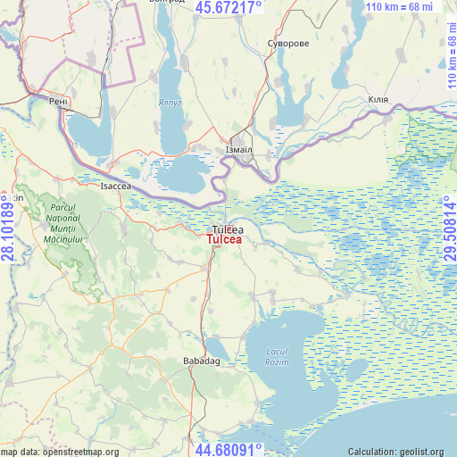
Tulcea GPS coordinates[2]
45° 10' 43.32" North, 28° 48' 18.036" East
| Map corner | latitude | longitude |
|---|---|---|
| Upper-left | 45.67217°, | 28.10189° |
| Center: | 45.1787°, | 28.80501° |
| Lower-right: | 44.68091°, | 29.50814° |
| Map W x H: | 110.2×110.2 km | = 68.5×68.5mi |
| max Lat: | 48.23793° ⇑62.7% North |
| Tulcea: | 45.1787° |
| min Lat: | ⇓37.3% South 43.65638° |
| min Long | Tulcea | max Long |
| 20.31667° | 28.80501° | 29.65403° |
| W 99.7%⇐ | ⇒0.3% E |
Elevation
Elevation of Tulcea is 34 m = 112 ft, and this is 220.9 m = 725 ft below average elevation for this country.
| Max E: |
1278 m = 4193 ft | 95.3% |
| Avg. | 254.9 m = 836 ft | |
| Tulcea | 34 m = 112 ft | |
Min E: |
-2 m = -7 ft | 4.7% |
See also: Tulcea elevation on elevation.city.
Geographical zone
Tulcea is located in North temperate zone (between Tropic of Cancer and the Arctic Circle). Distance of this North polar circle is 2377.8 km =1477.5 mi to North.| Distance of | km | miles | from Tulcea |
|---|---|---|---|
| North Pole | 4983.7 | 3096.7 | to North |
| Arctic Circle | 2377.8 | 1477.5 | to North |
| Tropic Cancer | 2417.5 | 1502.2 | to South |
| Equator | 5023.4 | 3121.4 | to South |


Nearby cities:
15 places around Tulcea: (largest is in red/bold)
• Agighiol
17.1 km =10.6 mi,  160°
160°
• Beștepe
19 km =11.8 mi,  120°
120°
• Cataloi
11 km =6.8 mi,  213°
213°
• Ceatalchioi
11.8 km =7.3 mi,  351°
351°
• Frecăţei
13.9 km =8.6 mi,  231°
231°
• Lăstuni
18.9 km =11.7 mi, 206°
• Malcoci
7.9 km =4.9 mi, 124°
• Mihail Kogălniceanu
17.1 km =10.6 mi,  199°
199°
• Mineri
7.2 km =4.5 mi,  257°
257°
• Nufăru
9.3 km =5.8 mi,  110°
110°
• Parcheș
17.1 km =10.6 mi,  282°
282°
• Pardina
18.5 km =11.5 mi,  43°
43°
• Poșta
15.8 km =9.8 mi,  243°
243°
• Somova
10.9 km =6.8 mi,  272°
272°
• Telița
18.8 km =11.7 mi, 261°
Sources, notices
• [Note1] Compared only with cities in Romania existing in our database
• [Src1] Map data: © OpenStreetMap contributors (CC-BY-SA)
• [Src2] Other city data from geonames.org with taken over terms of usage.
• [Src3] Geographical zone / Annual Mean Temperature by Robert A. Rohde @ Wikipedia
