Beștepe geodata
Beștepe (Tulcea) is a seat of a second-order administrative division; located in Romania in Europe/Bucharest (GMT+3) time zone. With population of 1,901 people, there are 2700 cities with bigger population in this country. Compared to other cities in Romania, 65.8% of cities are located further ↑North; 99.8% of cities are located further ←West and 99% of cities have higher elevation than Beștepe. Note1


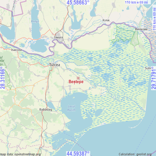
Beștepe GPS coordinates[2]
45° 5' 32.676" North, 29° 0' 53.208" East
| Map corner | latitude | longitude |
|---|---|---|
| Upper-left | 45.58663°, | 28.31166° |
| Center: | 45.09241°, | 29.01478° |
| Lower-right: | 44.59387°, | 29.71791° |
| Map W x H: | 110.4×110.4 km | = 68.6×68.6mi |
| max Lat: | 48.23793° ⇑65.8% North |
| Beștepe: | 45.09241° |
| min Lat: | ⇓34.2% South 43.65638° |
| min Long | Beștepe | max Long |
| 20.31667° | 29.01478° | 29.65403° |
| W 99.8%⇐ | ⇒0.2% E |
Elevation
Elevation of Beștepe is 11 m = 36 ft, and this is 243.9 m = 800 ft below average elevation for this country.
| Max E: |
1278 m = 4193 ft | 99% |
| Avg. | 254.9 m = 836 ft | |
| Beștepe | 11 m = 36 ft | |
Min E: |
-2 m = -7 ft | 1% |
See also: Romania elevation on elevation.city.
Geographical zone
Beștepe is located in North temperate zone (between Tropic of Cancer and the Arctic Circle). Distance of this North polar circle is 2387.4 km =1483.5 mi to North.| Distance of | km | miles | from Beștepe |
|---|---|---|---|
| North Pole | 4993.3 | 3102.7 | to North |
| Arctic Circle | 2387.4 | 1483.5 | to North |
| Tropic Cancer | 2407.9 | 1496.2 | to South |
| Equator | 5013.8 | 3115.4 | to South |


Nearby cities:
15 places around Beștepe: (largest is in red/bold)
• Agighiol
12.7 km =7.9 mi,  238°
238°
• Cataloi
22.5 km =14 mi,  270°
270°
• Dunavățu de Jos
19.7 km =12.2 mi,  125°
125°
• Iazurile
9.7 km =6 mi,  215°
215°
• Mahmudia
5.5 km =3.4 mi,  100°
100°
• Malcoci
11.2 km =7 mi,  297°
297°
• Maliuc
12.2 km =7.6 mi,  39°
39°
• Murighiol
13.6 km =8.5 mi,  118°
118°
• Nufăru
10 km =6.2 mi,  309°
309°
• Plopul
11.8 km =7.3 mi, 131°
• Sabangia
16.6 km =10.3 mi, 218°
• Sarichioi
20.5 km =12.7 mi, 219°
• Sarinasuf
9.9 km =6.2 mi,  157°
157°
• Tulcea
19 km =11.8 mi, 300°
• Valea Nucarilor
9.2 km =5.7 mi, 224°
Sources, notices
• [Note1] Compared only with cities in Romania existing in our database
• [Src1] Map data: © OpenStreetMap contributors (CC-BY-SA)
• [Src2] Other city data from geonames.org with taken over terms of usage.
• [Src3] Geographical zone / Annual Mean Temperature by Robert A. Rohde @ Wikipedia
