Telița geodata
Telița (Tulcea) is a populated place; located in Romania in Europe/Bucharest (GMT+3) time zone. With population of 720 people, there are 5464 cities with bigger population in this country. Compared to other cities in Romania, 63.3% of cities are located further ↑North; 99% of cities are located further ←West and 67% of cities have higher elevation than Telița. Note1


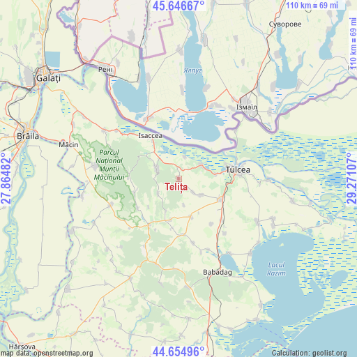
Telița GPS coordinates[2]
45° 9' 10.692" North, 28° 34' 4.584" East
| Map corner | latitude | longitude |
|---|---|---|
| Upper-left | 45.64667°, | 27.86482° |
| Center: | 45.15297°, | 28.56794° |
| Lower-right: | 44.65496°, | 29.27107° |
| Map W x H: | 110.3×110.3 km | = 68.5×68.5mi |
| max Lat: | 48.23793° ⇑63.3% North |
| Telița: | 45.15297° |
| min Lat: | ⇓36.7% South 43.65638° |
| min Long | Telița | max Long |
| 20.31667° | 28.56794° | 29.65403° |
| W 99%⇐ | ⇒1% E |
Elevation
Elevation of Telița is 139 m = 456 ft, and this is 115.9 m = 380 ft below average elevation for this country.
| Max E: |
1278 m = 4193 ft | 67% |
| Avg. | 254.9 m = 836 ft | |
| Telița | 139 m = 456 ft | |
Min E: |
-2 m = -7 ft | 33% |
See also: Romania elevation on elevation.city.
Geographical zone
Telița is located in North temperate zone (between Tropic of Cancer and the Arctic Circle). Distance of this North polar circle is 2380.6 km =1479.2 mi to North.| Distance of | km | miles | from Telița |
|---|---|---|---|
| North Pole | 4986.5 | 3098.5 | to North |
| Arctic Circle | 2380.6 | 1479.2 | to North |
| Tropic Cancer | 2414.6 | 1500.4 | to South |
| Equator | 5020.5 | 3119.6 | to South |


Nearby cities:
15 places around Telița: (largest is in red/bold)
• Cataloi
14.1 km =8.8 mi,  116°
116°
• Frecăţei
9.7 km =6 mi,  127°
127°
• Hamcearca
16.3 km =10.1 mi,  255°
255°
• Horia
17.8 km =11.1 mi,  211°
211°
• Isaccea
14.9 km =9.3 mi,  327°
327°
• Izvoarele
13.6 km =8.5 mi,  191°
191°
• Lăstuni
17.3 km =10.7 mi,  144°
144°
• Mineri
11.7 km =7.3 mi,  83°
83°
• Nalbant
12.1 km =7.5 mi,  161°
161°
• Nicolae Bălcescu
17.4 km =10.8 mi,  174°
174°
• Niculiţel
7.4 km =4.6 mi,  296°
296°
• Parcheș
6.9 km =4.3 mi,  16°
16°
• Poșta
6.1 km =3.8 mi, 132°
• Somova
8.4 km =5.2 mi,  66°
66°
• Valea Teilor
7.8 km =4.8 mi,  233°
233°
Sources, notices
• [Note1] Compared only with cities in Romania existing in our database
• [Src1] Map data: © OpenStreetMap contributors (CC-BY-SA)
• [Src2] Other city data from geonames.org with taken over terms of usage.
• [Src3] Geographical zone / Annual Mean Temperature by Robert A. Rohde @ Wikipedia
