Trestioara geodata
Trestioara (Gorj) is a populated place; located in Romania in Europe/Bucharest (GMT+3) time zone. With population of 539 people, there are 6689 cities with bigger population in this country. Compared to other cities in Romania, 77.5% of cities are located further ↑North; 81.9% of cities are located further →East and 50.5% of cities have lower elevation than Trestioara. Note1


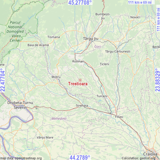
Trestioara GPS coordinates[2]
44° 46' 48.54" North, 23° 10' 48.576" East
| Map corner | latitude | longitude |
|---|---|---|
| Upper-left | 45.27708°, | 22.47704° |
| Center: | 44.78015°, | 23.18016° |
| Lower-right: | 44.2789°, | 23.88329° |
| Map W x H: | 111×111 km | = 69×69mi |
| max Lat: | 48.23793° ⇑77.5% North |
| Trestioara: | 44.78015° |
| min Lat: | ⇓22.5% South 43.65638° |
| min Long | Trestioara | max Long |
| 20.31667° | 23.18016° | 29.65403° |
| W 18.1%⇐ | ⇒81.9% E |
Elevation
Elevation of Trestioara is 214 m = 702 ft, and this is 40.9 m = 134 ft below average elevation for this country.
| Max E: |
1278 m = 4193 ft | 49.5% |
| Avg. | 254.9 m = 836 ft | |
| Trestioara | 214 m = 702 ft | |
Min E: |
-2 m = -7 ft | 50.5% |
See also: Romania elevation on elevation.city.
Geographical zone
Trestioara is located in North temperate zone (between Tropic of Cancer and the Arctic Circle). Distance of this Northern Tropic circle is 2373.2 km =1474.6 mi to South.| Distance of | km | miles | from Trestioara |
|---|---|---|---|
| North Pole | 5028 | 3124.3 | to North |
| Arctic Circle | 2422.1 | 1505 | to North |
| Tropic Cancer | 2373.2 | 1474.6 | to South |
| Equator | 4979.1 | 3093.9 | to South |


Nearby cities:
15 places around Trestioara: (largest is in red/bold)
• Artanu
3.4 km =2.1 mi,  76°
76°
• Bolboşi
4.4 km =2.7 mi,  139°
139°
• Bălăcești
3.3 km =2.1 mi,  154°
154°
• Corobăi
3.2 km =2 mi,  312°
312°
• Covrigi
5.3 km =3.3 mi,  207°
207°
• Croici
8.7 km =5.4 mi, 311°
• Drăgoteşti
2.5 km =1.6 mi,  334°
334°
• Miluta
8.5 km =5.3 mi,  183°
183°
• Negomir
6 km =3.7 mi,  349°
349°
• Ohaba Jiu
8.5 km =5.3 mi, 141°
• Peșteana de Jos
9.2 km =5.7 mi,  50°
50°
• Slivileşti
3.7 km =2.3 mi,  275°
275°
• Strâmtu
5.3 km =3.3 mi,  265°
265°
• Ursoaia
4.4 km =2.7 mi,  32°
32°
• Valea
6.7 km =4.2 mi,  164°
164°
Sources, notices
• [Note1] Compared only with cities in Romania existing in our database
• [Src1] Map data: © OpenStreetMap contributors (CC-BY-SA)
• [Src2] Other city data from geonames.org with taken over terms of usage.
• [Src3] Geographical zone / Annual Mean Temperature by Robert A. Rohde @ Wikipedia
