Negomir geodata
Negomir (Gorj) is a seat of a second-order administrative division; located in Romania in Europe/Bucharest (GMT+3) time zone. With population of 580 people, there are 6357 cities with bigger population in this country. Compared to other cities in Romania, 75.6% of cities are located further ↑North; 82.1% of cities are located further →East and 51.3% of cities have lower elevation than Negomir. Note1


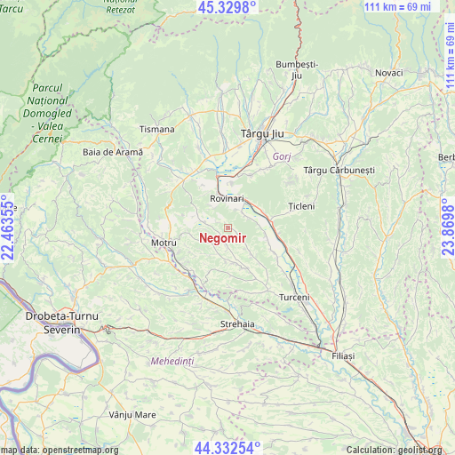
Negomir GPS coordinates[2]
44° 49' 59.988" North, 23° 10' 0.012" East
| Map corner | latitude | longitude |
|---|---|---|
| Upper-left | 45.3298°, | 22.46355° |
| Center: | 44.83333°, | 23.16667° |
| Lower-right: | 44.33254°, | 23.8698° |
| Map W x H: | 110.9×110.9 km | = 68.9×68.9mi |
| max Lat: | 48.23793° ⇑75.6% North |
| Negomir: | 44.83333° |
| min Lat: | ⇓24.4% South 43.65638° |
| min Long | Negomir | max Long |
| 20.31667° | 23.16667° | 29.65403° |
| W 17.9%⇐ | ⇒82.1% E |
Elevation
Elevation of Negomir is 218 m = 715 ft, and this is 36.9 m = 121 ft below average elevation for this country.
| Max E: |
1278 m = 4193 ft | 48.7% |
| Avg. | 254.9 m = 836 ft | |
| Negomir | 218 m = 715 ft | |
Min E: |
-2 m = -7 ft | 51.3% |
See also: Romania elevation on elevation.city.
Geographical zone
Negomir is located in North temperate zone (between Tropic of Cancer and the Arctic Circle). Distance of this Northern Tropic circle is 2379.1 km =1478.3 mi to South.| Distance of | km | miles | from Negomir |
|---|---|---|---|
| North Pole | 5022.1 | 3120.6 | to North |
| Arctic Circle | 2416.2 | 1501.4 | to North |
| Tropic Cancer | 2379.1 | 1478.3 | to South |
| Equator | 4985 | 3097.5 | to South |


Nearby cities:
15 places around Negomir: (largest is in red/bold)
• Artanu
6.7 km =4.2 mi,  139°
139°
• Brădet
8.3 km =5.2 mi,  296°
296°
• Corobăi
3.9 km =2.4 mi,  199°
199°
• Croici
5.5 km =3.4 mi,  267°
267°
• Drăgoteşti
3.7 km =2.3 mi,  180°
180°
• Fărcăşeşti
4.5 km =2.8 mi,  35°
35°
• Moi
8.2 km =5.1 mi,  23°
23°
• Mătăsari
6.8 km =4.2 mi,  285°
285°
• Peșteana de Jos
8.1 km =5 mi,  90°
90°
• Roșia Jiu
6.3 km =3.9 mi,  357°
357°
• Slivileşti
6.2 km =3.9 mi,  205°
205°
• Strâmtu
7.6 km =4.7 mi, 213°
• Trestioara
6 km =3.7 mi,  169°
169°
• Ursoaia
4.1 km =2.5 mi,  123°
123°
• Vlăduleni
8.3 km =5.2 mi, 42°
Sources, notices
• [Note1] Compared only with cities in Romania existing in our database
• [Src1] Map data: © OpenStreetMap contributors (CC-BY-SA)
• [Src2] Other city data from geonames.org with taken over terms of usage.
• [Src3] Geographical zone / Annual Mean Temperature by Robert A. Rohde @ Wikipedia
