Toporăști geodata
Toporăști (Vaslui) is a populated place; located in Romania in Europe/Bucharest (GMT+3) time zone. With population of 654 people, there are 5863 cities with bigger population in this country. Compared to other cities in Romania, 71.5% of cities are located further ↓South; 89.7% of cities are located further ←West and 54.8% of cities have higher elevation than Toporăști. Note1


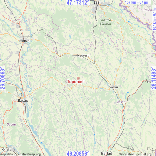
Toporăști GPS coordinates[2]
46° 41' 34.764" North, 27° 24' 42.48" East
| Map corner | latitude | longitude |
|---|---|---|
| Upper-left | 47.17312°, | 26.70868° |
| Center: | 46.69299°, | 27.4118° |
| Lower-right: | 46.20856°, | 28.11493° |
| Map W x H: | 107.2×107.2 km | = 66.6×66.6mi |
| max Lat: | 48.23793° ⇑28.5% North |
| Toporăști: | 46.69299° |
| min Lat: | ⇓71.5% South 43.65638° |
| min Long | Toporăști | max Long |
| 20.31667° | 27.4118° | 29.65403° |
| W 89.7%⇐ | ⇒10.3% E |
Elevation
Elevation of Toporăști is 188 m = 617 ft, and this is 66.9 m = 219 ft below average elevation for this country.
| Max E: |
1278 m = 4193 ft | 54.8% |
| Avg. | 254.9 m = 836 ft | |
| Toporăști | 188 m = 617 ft | |
Min E: |
-2 m = -7 ft | 45.2% |
See also: Romania elevation on elevation.city.
Geographical zone
Toporăști is located in North temperate zone (between Tropic of Cancer and the Arctic Circle). Distance of this North polar circle is 2209.4 km =1372.9 mi to North.| Distance of | km | miles | from Toporăști |
|---|---|---|---|
| North Pole | 4815.3 | 2992.1 | to North |
| Arctic Circle | 2209.4 | 1372.9 | to North |
| Tropic Cancer | 2585.9 | 1606.8 | to South |
| Equator | 5191.8 | 3226 | to South |


Nearby cities:
15 places around Toporăști: (largest is in red/bold)
• Armășoaia
2.2 km =1.4 mi,  256°
256°
• Buda
7.7 km =4.8 mi,  5°
5°
• Bălești
9.2 km =5.7 mi,  76°
76°
• Cozmești
8.2 km =5.1 mi,  56°
56°
• Deleşti
10.6 km =6.6 mi,  85°
85°
• Doagele
6.5 km =4 mi,  247°
247°
• Dragomireşti
8.1 km =5 mi,  215°
215°
• Fundătura
9.1 km =5.7 mi,  95°
95°
• Fâstâci
5.1 km =3.2 mi,  34°
34°
• Hârsova
10.6 km =6.6 mi, 103°
• Ivănești
7.5 km =4.7 mi,  150°
150°
• Oşeşti
9.2 km =5.7 mi, 27°
• Pungeşti
6 km =3.7 mi,  277°
277°
• Rădeni
11.7 km =7.3 mi,  193°
193°
• Satu Nou
8.6 km =5.3 mi,  266°
266°
Sources, notices
• [Note1] Compared only with cities in Romania existing in our database
• [Src1] Map data: © OpenStreetMap contributors (CC-BY-SA)
• [Src2] Other city data from geonames.org with taken over terms of usage.
• [Src3] Geographical zone / Annual Mean Temperature by Robert A. Rohde @ Wikipedia
