Rădeni geodata
Rădeni (Vaslui) is a populated place; located in Romania in Europe/Bucharest (GMT+3) time zone. With population of 996 people, there are 4308 cities with bigger population in this country. Compared to other cities in Romania, 69.2% of cities are located further ↓South; 89.4% of cities are located further ←West and 63.7% of cities have higher elevation than Rădeni. Note1


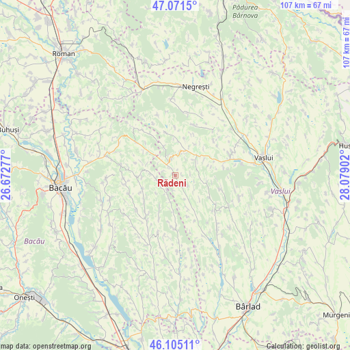
Rădeni GPS coordinates[2]
46° 35' 25.656" North, 27° 22' 33.204" East
| Map corner | latitude | longitude |
|---|---|---|
| Upper-left | 47.0715°, | 26.67277° |
| Center: | 46.59046°, | 27.37589° |
| Lower-right: | 46.10511°, | 28.07902° |
| Map W x H: | 107.5×107.5 km | = 66.8×66.8mi |
| max Lat: | 48.23793° ⇑30.8% North |
| Rădeni: | 46.59046° |
| min Lat: | ⇓69.2% South 43.65638° |
| min Long | Rădeni | max Long |
| 20.31667° | 27.37589° | 29.65403° |
| W 89.4%⇐ | ⇒10.6% E |
Elevation
Elevation of Rădeni is 152 m = 499 ft, and this is 102.9 m = 338 ft below average elevation for this country.
| Max E: |
1278 m = 4193 ft | 63.7% |
| Avg. | 254.9 m = 836 ft | |
| Rădeni | 152 m = 499 ft | |
Min E: |
-2 m = -7 ft | 36.3% |
See also: Romania elevation on elevation.city.
Geographical zone
Rădeni is located in North temperate zone (between Tropic of Cancer and the Arctic Circle). Distance of this North polar circle is 2220.8 km =1379.9 mi to North.| Distance of | km | miles | from Rădeni |
|---|---|---|---|
| North Pole | 4826.7 | 2999.2 | to North |
| Arctic Circle | 2220.8 | 1379.9 | to North |
| Tropic Cancer | 2574.5 | 1599.7 | to South |
| Equator | 5180.4 | 3219 | to South |


Nearby cities:
15 places around Rădeni: (largest is in red/bold)
• Armășoaia
10.9 km =6.8 mi,  3°
3°
• Avrămești
4.5 km =2.8 mi,  191°
191°
• Barcana
11.4 km =7.1 mi, 185°
• Coloneşti
6.4 km =4 mi,  245°
245°
• Doagele
9.5 km =5.9 mi,  339°
339°
• Dragomireşti
5.2 km =3.2 mi, 337°
• Gârdești
7.2 km =4.5 mi,  128°
128°
• Ivănești
8.1 km =5 mi,  52°
52°
• Izvoru Berheciului
12.2 km =7.6 mi,  266°
266°
• Poieneşti
12.4 km =7.7 mi,  76°
76°
• Satu Nou
12.4 km =7.7 mi,  331°
331°
• Slobozia Nouă
8.2 km =5.1 mi,  226°
226°
• Tarnița
12.1 km =7.5 mi, 230°
• Toporăști
11.7 km =7.3 mi,  13°
13°
• Voineşti
4.1 km =2.5 mi, 130°
Sources, notices
• [Note1] Compared only with cities in Romania existing in our database
• [Src1] Map data: © OpenStreetMap contributors (CC-BY-SA)
• [Src2] Other city data from geonames.org with taken over terms of usage.
• [Src3] Geographical zone / Annual Mean Temperature by Robert A. Rohde @ Wikipedia
