Târnăveni geodata
Târnăveni (Mureş) is a seat of a second-order administrative division; located in Romania in Europe/Bucharest (GMT+3) time zone. With population of 28,634 people, there are 78 cities with bigger population in this country. Compared to other cities in Romania, 62.9% of cities are located further ↓South; 63.9% of cities are located further →East and 64% of cities have lower elevation than Târnăveni. Note1


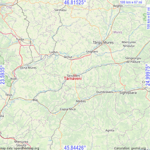
Târnăveni GPS coordinates[2]
46° 19' 54.876" North, 24° 17' 47.832" East
| Map corner | latitude | longitude |
|---|---|---|
| Upper-left | 46.81525°, | 23.5935° |
| Center: | 46.33191°, | 24.29662° |
| Lower-right: | 45.84426°, | 24.99975° |
| Map W x H: | 108×108 km | = 67.1×67.1mi |
| max Lat: | 48.23793° ⇑37.1% North |
| Târnăveni: | 46.33191° |
| min Lat: | ⇓62.9% South 43.65638° |
| min Long | Târnăveni | max Long |
| 20.31667° | 24.29662° | 29.65403° |
| W 36.1%⇐ | ⇒63.9% E |
Elevation
Elevation of Târnăveni is 284 m = 932 ft, and this is 29.1 m = 95 ft above average elevation for this country.
| Max E: |
1278 m = 4193 ft | 36% |
| Târnăveni | 284 m 932 ft | |
| Avg. | 254.9 m = 836 ft | |
Min E: |
-2 m = -7 ft | 64% |
See also: Romania elevation on elevation.city.
Geographical zone
Târnăveni is located in North temperate zone (between Tropic of Cancer and the Arctic Circle). Distance of this North polar circle is 2249.5 km =1397.8 mi to North.| Distance of | km | miles | from Târnăveni |
|---|---|---|---|
| North Pole | 4855.4 | 3017 | to North |
| Arctic Circle | 2249.5 | 1397.8 | to North |
| Tropic Cancer | 2545.7 | 1581.8 | to South |
| Equator | 5151.6 | 3201.1 | to South |


Nearby cities:
15 places around Târnăveni: (largest is in red/bold)
• Adămuş
6 km =3.7 mi,  233°
233°
• Bobohalma
5.5 km =3.4 mi,  294°
294°
• Băgaciu
9 km =5.6 mi,  143°
143°
• Cornești
7.8 km =4.8 mi,  235°
235°
• Crăieşti
9.4 km =5.8 mi,  247°
247°
• Cucerdea
7.9 km =4.9 mi,  343°
343°
• Cuștelnic
1.4 km =0.9 mi,  56°
56°
• Deaj
8.3 km =5.2 mi,  78°
78°
• Deleni
8.4 km =5.2 mi,  155°
155°
• Dâmbău
5 km =3.1 mi, 254°
• Găneşti
4.1 km =2.5 mi,  87°
87°
• Hărănglab
9.6 km =6 mi,  108°
108°
• Mica
10 km =6.2 mi,  67°
67°
• Velț
10.4 km =6.5 mi,  186°
186°
• Șeulia de Mureș
10.1 km =6.3 mi, 337°
Sources, notices
• [Note1] Compared only with cities in Romania existing in our database
• [Src1] Map data: © OpenStreetMap contributors (CC-BY-SA)
• [Src2] Other city data from geonames.org with taken over terms of usage.
• [Src3] Geographical zone / Annual Mean Temperature by Robert A. Rohde @ Wikipedia
