Băgaciu geodata
Băgaciu (Mureş) is a seat of a second-order administrative division; located in Romania in Europe/Bucharest (GMT+3) time zone. With population of 2,549 people, there are 2115 cities with bigger population in this country. Compared to other cities in Romania, 61.1% of cities are located further ↓South; 62.4% of cities are located further →East and 78.3% of cities have lower elevation than Băgaciu. Note1


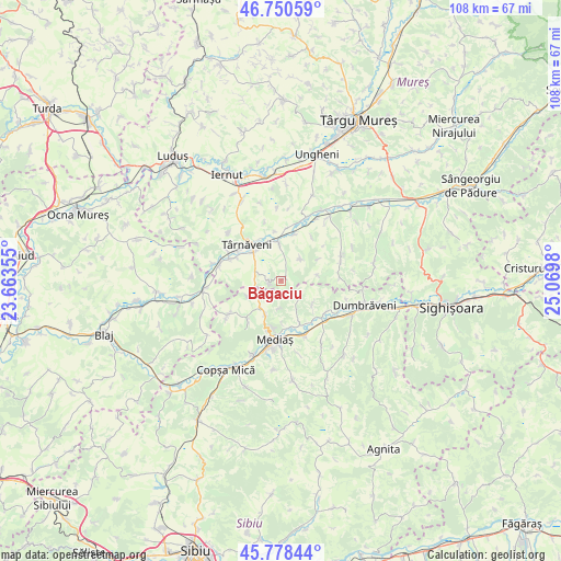
Băgaciu GPS coordinates[2]
46° 16' 0.012" North, 24° 22' 0.012" East
| Map corner | latitude | longitude |
|---|---|---|
| Upper-left | 46.75059°, | 23.66355° |
| Center: | 46.26667°, | 24.36667° |
| Lower-right: | 45.77844°, | 25.0698° |
| Map W x H: | 108.1×108.1 km | = 67.2×67.2mi |
| max Lat: | 48.23793° ⇑38.9% North |
| Băgaciu: | 46.26667° |
| min Lat: | ⇓61.1% South 43.65638° |
| min Long | Băgaciu | max Long |
| 20.31667° | 24.36667° | 29.65403° |
| W 37.6%⇐ | ⇒62.4% E |
Elevation
Elevation of Băgaciu is 379 m = 1243 ft, and this is 124.1 m = 407 ft above average elevation for this country.
| Max E: |
1278 m = 4193 ft | 21.7% |
| Băgaciu | 379 m 1243 ft | |
| Avg. | 254.9 m = 836 ft | |
Min E: |
-2 m = -7 ft | 78.3% |
See also: Romania elevation on elevation.city.
Geographical zone
Băgaciu is located in North temperate zone (between Tropic of Cancer and the Arctic Circle). Distance of this North polar circle is 2256.8 km =1402.3 mi to North.| Distance of | km | miles | from Băgaciu |
|---|---|---|---|
| North Pole | 4862.7 | 3021.5 | to North |
| Arctic Circle | 2256.8 | 1402.3 | to North |
| Tropic Cancer | 2538.5 | 1577.4 | to South |
| Equator | 5144.4 | 3196.6 | to South |


Nearby cities:
15 places around Băgaciu: (largest is in red/bold)
• Alma
10.5 km =6.5 mi,  124°
124°
• Bazna
9.8 km =6.1 mi,  220°
220°
• Blăjel
6.8 km =4.2 mi,  214°
214°
• Ceuaș
10.3 km =6.4 mi,  34°
34°
• Curciu
4 km =2.5 mi,  128°
128°
• Cuștelnic
9.1 km =5.7 mi,  332°
332°
• Deaj
9.3 km =5.8 mi,  16°
16°
• Deleni
2 km =1.2 mi,  259°
259°
• Dârlos
9.6 km =6 mi,  164°
164°
• Găneşti
7.5 km =4.7 mi,  350°
350°
• Hărănglab
5.7 km =3.5 mi,  41°
41°
• Păucea
5.4 km =3.4 mi,  186°
186°
• Târnăveni
9 km =5.6 mi,  323°
323°
• Velț
7.3 km =4.5 mi,  245°
245°
• Șmig
7.6 km =4.7 mi, 127°
Sources, notices
• [Note1] Compared only with cities in Romania existing in our database
• [Src1] Map data: © OpenStreetMap contributors (CC-BY-SA)
• [Src2] Other city data from geonames.org with taken over terms of usage.
• [Src3] Geographical zone / Annual Mean Temperature by Robert A. Rohde @ Wikipedia
