Hărănglab geodata
Hărănglab (Mureş) is a populated place; located in Romania in Europe/Bucharest (GMT+3) time zone. With population of 866 people, there are 4767 cities with bigger population in this country. Compared to other cities in Romania, 62.3% of cities are located further ↓South; 61.5% of cities are located further →East and 71.1% of cities have lower elevation than Hărănglab. Note1


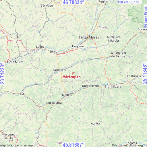
Hărănglab GPS coordinates[2]
46° 18' 17.136" North, 24° 24' 55.26" East
| Map corner | latitude | longitude |
|---|---|---|
| Upper-left | 46.78834°, | 23.71223° |
| Center: | 46.30476°, | 24.41535° |
| Lower-right: | 45.81687°, | 25.11848° |
| Map W x H: | 108×108 km | = 67.1×67.1mi |
| max Lat: | 48.23793° ⇑37.7% North |
| Hărănglab: | 46.30476° |
| min Lat: | ⇓62.3% South 43.65638° |
| min Long | Hărănglab | max Long |
| 20.31667° | 24.41535° | 29.65403° |
| W 38.5%⇐ | ⇒61.5% E |
Elevation
Elevation of Hărănglab is 328 m = 1076 ft, and this is 73.1 m = 240 ft above average elevation for this country.
| Max E: |
1278 m = 4193 ft | 28.9% |
| Hărănglab | 328 m 1076 ft | |
| Avg. | 254.9 m = 836 ft | |
Min E: |
-2 m = -7 ft | 71.1% |
See also: Romania elevation on elevation.city.
Geographical zone
Hărănglab is located in North temperate zone (between Tropic of Cancer and the Arctic Circle). Distance of this North polar circle is 2252.6 km =1399.7 mi to North.| Distance of | km | miles | from Hărănglab |
|---|---|---|---|
| North Pole | 4858.5 | 3018.9 | to North |
| Arctic Circle | 2252.6 | 1399.7 | to North |
| Tropic Cancer | 2542.7 | 1580 | to South |
| Equator | 5148.6 | 3199.2 | to South |


Nearby cities:
15 places around Hărănglab: (largest is in red/bold)
• Bahnea
8.6 km =5.3 mi,  37°
37°
• Băgaciu
5.7 km =3.5 mi,  221°
221°
• Ceuaș
4.8 km =3 mi,  26°
26°
• Curciu
6.8 km =4.2 mi,  185°
185°
• Cuștelnic
8.8 km =5.5 mi,  295°
295°
• Deaj
4.8 km =3 mi,  347°
347°
• Deleni
7.3 km =4.5 mi,  231°
231°
• Gogan
7.8 km =4.8 mi,  89°
89°
• Găneşti
5.9 km =3.7 mi, 302°
• Idrifaia
9.9 km =6.2 mi,  22°
22°
• Mica
6.9 km =4.3 mi,  0°
0°
• Păucea
10.5 km =6.5 mi,  204°
204°
• Sântioana
10.7 km =6.6 mi,  102°
102°
• Târnăveni
9.6 km =6 mi,  288°
288°
• Șmig
9.1 km =5.7 mi,  165°
165°
Sources, notices
• [Note1] Compared only with cities in Romania existing in our database
• [Src1] Map data: © OpenStreetMap contributors (CC-BY-SA)
• [Src2] Other city data from geonames.org with taken over terms of usage.
• [Src3] Geographical zone / Annual Mean Temperature by Robert A. Rohde @ Wikipedia
